
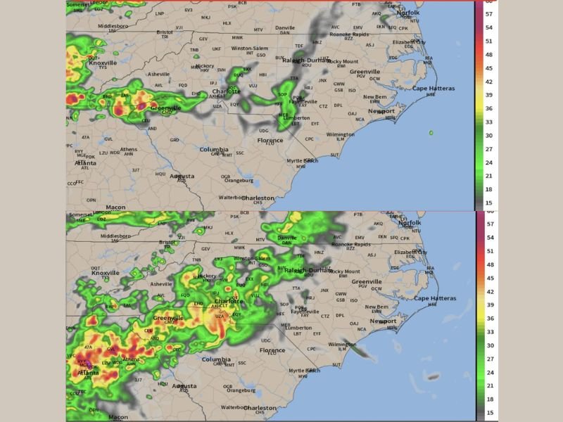
Heavy Rain, Gusty Winds and Isolated Severe Risk Hitting Western NC Mountains and Foothills Wednesday Evening Spreading Into Central and Eastern NC Through Thursday Morning
NORTH CAROLINA — A cold front approaching from the west is bringing scattered showers and thunderstorms into the North Carolina mountains and foothills this evening, Wednesday May 6, 2026, with activity pushing eastward through the overnight hours into Thursday morning. Heavy rainfall bursts of 1 to 2 inches and gusty winds represent the primary threats, with an isolated severe storm risk persisting until midnight across western NC. Rainfall will not be evenly distributed, creating winners and losers across the state with some areas seeing meaningful totals while others receive very little.
Mountains and Foothills Face Isolated Severe Risk Until Midnight Wednesday
Scattered showers and thunderstorms will move into the NC mountains and foothills this evening, producing bursts of heavy rainfall and gusty winds through the overnight hours. An isolated severe storm risk exists until around midnight for parts of western NC, with damaging winds and hail the threats if any storms become stronger.
The overall severe risk is described as rather low but not zero, making weather awareness necessary for communities across the western NC mountain and foothill zones through the late evening hours.
Storms Push East Into Central and Eastern NC Thursday Morning Through Afternoon
Scattered showers and thunderstorms will push east overnight, reaching Central and Eastern NC by Thursday morning and continuing through parts of the afternoon and evening. Raleigh-Durham, Greenville, New Bern, Wilmington, and surrounding communities will track increasing storm activity through the Thursday morning and midday window.
Severe weather remains unlikely Thursday but a stronger storm with gusty winds cannot be completely ruled out across the eastern portions of the state.
Uneven Rainfall Creates Winners and Losers With Localized Flooding Possible
Rainfall totals will vary dramatically depending on where heavier rain bands set up across the state. Some locations will receive 1 to 2 inches while others see very little, making the distribution highly unpredictable through the event.
Despite ongoing dry conditions, localized flooding remains possible wherever heavier rain bands train repeatedly over the same area due to dry ground causing rapid runoff. Stay with NapervilleLocal.com for the latest weather updates and local forecast coverage.

I’ve lived in Naperville long enough to see how quickly our community changes — from new developments downtown to sudden shifts in our Midwest weather. Reporting on Naperville news and daily forecasts gives me the chance to keep neighbors informed about what really matters. My goal is simple: deliver clear, timely updates so you always know what’s happening in our city and what to expect from the skies above.