
Below Average Temperatures and Frost Risks Locking In Across the Midwest and Great Lakes Through Late May With Upper 40s and 50s Dominating May 6 Through May 20
MIDWEST — A stubborn and prolonged cool pattern is now confirmed to linger across the Midwest and Great Lakes region through at least May 20, 2026, with forecast models and ensembles in agreement that below average temperatures will dominate the next two weeks. Upper 40s and 50s will be the daily reality for most of the region, with only occasional 60s and brief touches of 70s possible when storm systems temporarily draw up warmer air. Those warmer days will be short-lived and accompanied by rain and storm chances rather than sustained warmth.
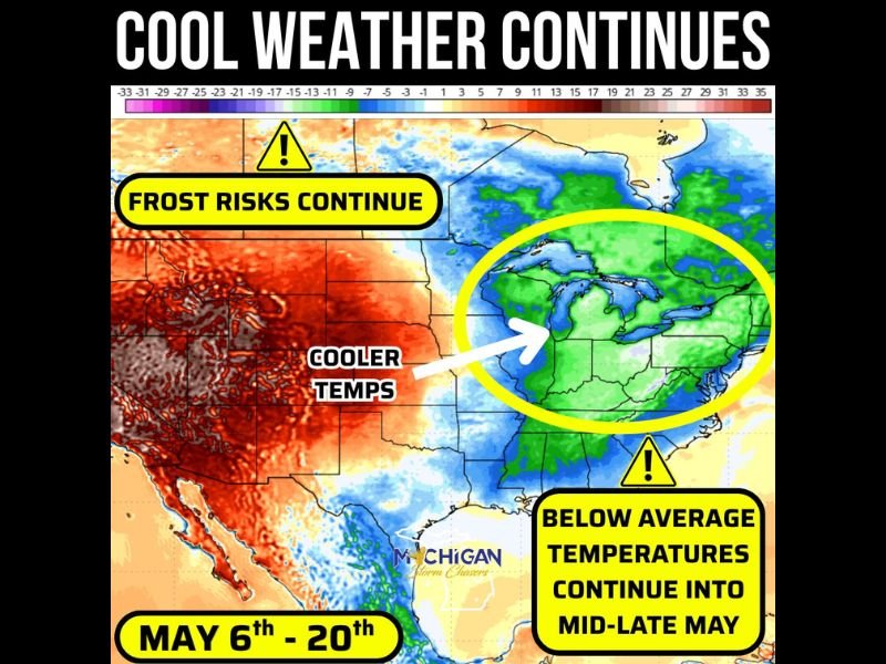
Below Average Temperatures Locked In Across Midwest and Great Lakes Through May 20
Temperature anomaly mapping shows a broad green and blue below average zone covering the entire Great Lakes region, Midwest, and extending into the Ohio Valley and Northeast through the May 6 to 20 timeframe. This cool pattern is not a brief dip but a sustained two-week stretch of temperatures running consistently below seasonal norms.
Occasional warmth reaching the 60s and briefly near 70 degrees will occur only during periods when storm systems pull warmer air northward temporarily before cooler air floods back in behind each system.
Frost Risks Continue Across the Region Through Mid to Late May
Frost risks are explicitly flagged as a continuing concern across the Midwest and Great Lakes zone through the duration of this cool pattern. With overnight temperatures capable of dropping into the 30s and potentially touching freezing on the coldest nights, sensitive plants, gardens, and crops remain vulnerable through mid to late May.
Residents across Michigan, Indiana, Ohio, Illinois, and surrounding states should not assume frost season is finished and should continue monitoring overnight temperature forecasts carefully through at least May 20.
Warmer Weather Eventually Coming But Not Before Late May Pattern Break
Warmer and more seasonable temperatures are expected to eventually return to the Midwest and Great Lakes region, but not before the cool pattern runs its course through at least May 20. Any warmth arriving before that date will be brief, storm-accompanied, and quickly replaced by the returning cool air mass dominating the region through the remainder of the month’s first three weeks. Stay with NapervilleLocal.com for the latest weather updates and local forecast coverage.

I’ve lived in Naperville long enough to see how quickly our community changes — from new developments downtown to sudden shifts in our Midwest weather. Reporting on Naperville news and daily forecasts gives me the chance to keep neighbors informed about what really matters. My goal is simple: deliver clear, timely updates so you always know what’s happening in our city and what to expect from the skies above.