
Large Hail, Damaging Winds and Brief Tornado Possible Across the Midwest Including Chicago, St. Louis and Indianapolis Tuesday With Threat Shifting to Ohio Valley and Northeast Wednesday
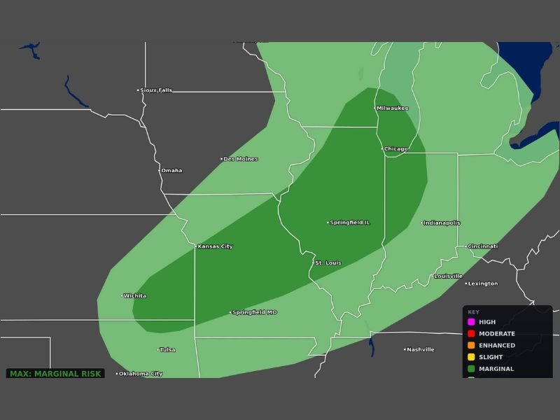
MIDWEST — More severe weather is possible across the Midwest on Tuesday, May 12, 2026, with large hail being the primary concern and damaging winds and a brief tornado also unable to be ruled out. The categorical outlook updated at 3:22 AM ET places a Marginal Risk zone across a broad corridor covering Chicago, Milwaukee, Springfield Illinois, St. Louis, Indianapolis, Kansas City, and Louisville. The severe threat area then shifts east toward the Ohio Valley and Northeast on Wednesday with more localized severe weather possible across that region.
Large Hail Primary Concern Across Marginal Risk Zone Covering Chicago Through St. Louis
The Marginal Risk inner core covers a broad north-south corridor from Milwaukee and Chicago southward through Springfield Illinois, St. Louis, and into Springfield Missouri and the surrounding region. Large hail represents the highest confidence hazard across this zone through Tuesday’s active weather window.
Any storm that develops and strengthens within this corridor will be capable of producing hail and gusty winds as the primary hazard combination through the afternoon and evening hours.
Damaging Winds and Brief Tornado Cannot Be Ruled Out Across the Risk Zone
Beyond the large hail threat, damaging winds and a brief tornado remain possible across the Marginal Risk zone covering the central Midwest on Tuesday. While the overall setup does not support a significant or widespread tornado outbreak, isolated storm organization during the peak heating hours could produce brief tornado development across portions of the risk corridor.
Residents across Chicago, St. Louis, Indianapolis, Kansas City, and surrounding communities should have weather alerts active through Tuesday afternoon and evening.
Threat Shifts East to Ohio Valley and Northeast Wednesday With Localized Severe Weather
Following Tuesday’s Midwest event, the severe weather threat area shifts eastward into the Ohio Valley and Northeast on Wednesday. More localized severe weather is possible across Cincinnati, Louisville, Lexington, and surrounding communities as the system continues pushing east through the mid-week period.
Residents across the broader Midwest and Ohio Valley region should monitor forecast updates through Tuesday for the latest details on both the Tuesday and Wednesday severe weather windows. Stay with NapervilleLocal.com for the latest weather updates and local forecast coverage.

I’ve lived in Naperville long enough to see how quickly our community changes — from new developments downtown to sudden shifts in our Midwest weather. Reporting on Naperville news and daily forecasts gives me the chance to keep neighbors informed about what really matters. My goal is simple: deliver clear, timely updates so you always know what’s happening in our city and what to expect from the skies above.