
Hail Over 2 Inches Possible Across Northeast Kansas Northern Missouri and Southern Iowa Including Kansas City Topeka Omaha and Des Moines Friday Evening May 15
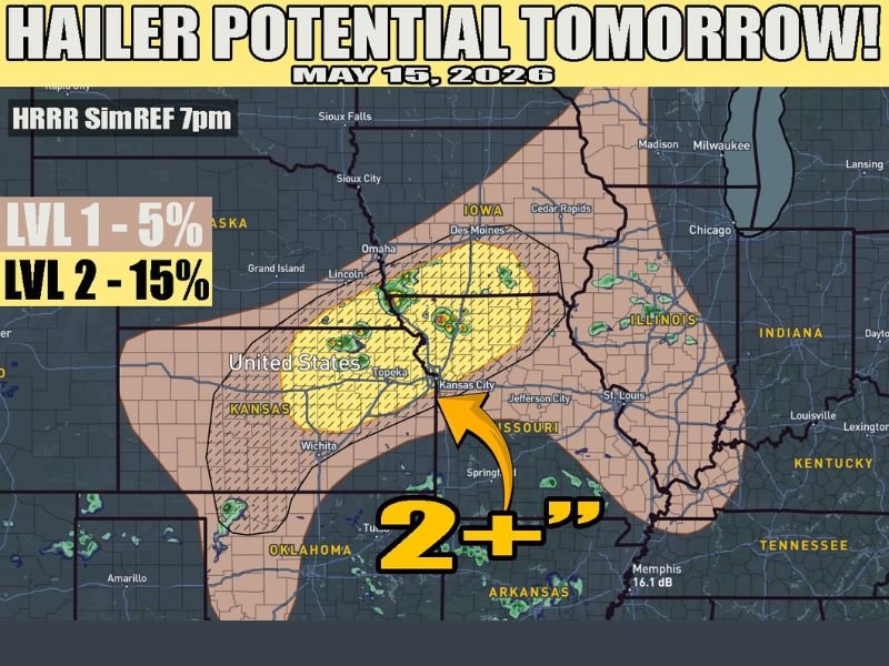
NORTHEAST KANSAS — A significant hail threat is developing for Friday evening, May 15, 2026, with northeast Kansas into northern Missouri and southern Iowa in the crosshairs as another wave of energy kicks off elevated or high-based storms. The Level 2 risk carries a 15 percent hail probability across the yellow-shaded core zone, with some hail potentially exceeding 2 inches in diameter.
The broader Level 1 zone at 5 percent fans outward through a large portion of Kansas, Missouri, Iowa, and into Illinois covering communities well beyond the immediate core threat area. HRRR model simulation valid at 7 PM shows storm activity concentrated across the northeast Kansas through Kansas City and Omaha corridor during the primary evening threat window.
Level 2 Core Covers Northeast Kansas Kansas City and Omaha With 2 Plus Inch Hail Potential
The yellow-shaded Level 2 zone centered over northeast Kansas stretching through the Kansas City corridor and northward toward Omaha carries the highest hail confidence for Friday evening. Hail exceeding 2 inches in diameter is possible with the strongest elevated or high-based storms firing within this zone during the late afternoon and evening hours.
Two-inch-plus hail is large enough to cause significant damage to vehicles, roofs, windows, and any exposed property or equipment. Residents across the Kansas City, Topeka, and Omaha areas should have vehicles sheltered and take precautions before storms arrive Friday evening.
Southern Iowa Including Des Moines Also Falls Within the Elevated Hail Risk Zone
Southern Iowa including the Des Moines corridor sits within the elevated hail risk zone on Friday’s outlook, extending the threat northward beyond the Kansas and Missouri core area. Storms tracking into this region during the evening hours carry the same hail potential as those firing further south across the primary threat zone.
Iowa residents from Des Moines southward through the state line should treat Friday evening with the same level of weather awareness as communities in the heart of the Kansas City risk corridor.
Tornado Chances Remain Low While Weekend Pattern Turns More Active
Tornado potential with Friday’s storm setup is expected to remain low, with the elevated and high-based storm mode limiting rotation chances across the outlined zone. However, the active weather pattern is far from over after Friday, with conditions expected to become significantly more active heading into the weekend and next week.
Anyone across northeast Kansas, northern Missouri, and southern Iowa should stay weather aware through Friday evening and begin monitoring updates for the more significant severe weather potential arriving this weekend. Stay with NapervilleLocal.com for the latest weather updates and local forecast coverage.

I’ve lived in Naperville long enough to see how quickly our community changes — from new developments downtown to sudden shifts in our Midwest weather. Reporting on Naperville news and daily forecasts gives me the chance to keep neighbors informed about what really matters. My goal is simple: deliver clear, timely updates so you always know what’s happening in our city and what to expect from the skies above.