
Severe Weather Outbreak With Strong Tornadoes Very Large Hail and Damaging Winds Targeting Kansas Through Michigan Including Omaha Kansas City Chicago and Detroit Monday May 18
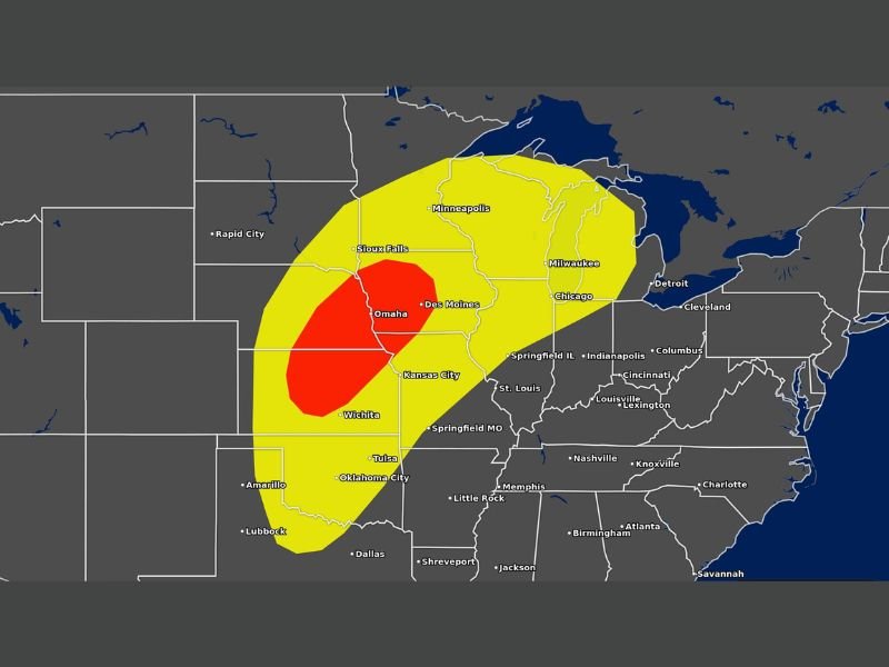
CENTRAL PLAINS — A severe weather outbreak is possible across a massive portion of the United States on Monday, May 18, 2026, with strong tornadoes, very large hail, and damaging winds all on the table from the southern Plains through the Great Lakes. The outlook shows a high-end Moderate Risk red zone centered over the Omaha, Des Moines, Wichita, and Kansas City corridor carrying a 30 percent severe weather probability, surrounded by a broad Slight Risk yellow zone extending through Chicago, Milwaukee, Minneapolis, Detroit, and Indianapolis.
The Kansas through Michigan corridor is the area of greatest concern for discrete supercells and organized lines of thunderstorms. This is a rapidly growing threat that is expected to increase in confidence and coverage as Monday approaches, and residents across all outlined zones should begin preparations immediately.
Moderate Risk Core Centered Over Omaha Kansas City and Wichita With 30 Percent Severe Probability
The red-shaded Moderate Risk zone covering Omaha, Des Moines, Kansas City, and Wichita carries the highest severe weather confidence on Monday’s outlook at 30 percent probability. Discrete supercells firing within this zone carry the greatest potential for all hazard types simultaneously, including strong and long-track tornadoes, very large hail, and destructive damaging winds.
The Kansas through Iowa corridor sitting inside the Moderate Risk core should treat Monday as a life-threatening severe weather situation requiring advance preparation and a confirmed shelter plan well before storms arrive.
Slight Risk Fans Through Chicago Milwaukee Minneapolis Detroit and Indianapolis
Surrounding the Moderate Risk core, a large Slight Risk yellow zone extends the significant severe weather threat outward through Chicago, Milwaukee, Minneapolis, Detroit, Indianapolis, St. Louis, and Springfield Illinois. Communities across this broader zone face a 15 percent severe weather probability, reflecting a real and meaningful threat even outside the highest risk corridor.
Lines of thunderstorms developing along and ahead of the main supercell activity could produce damaging winds across this wider zone well into the evening hours on Monday.
Residents From Kansas Through Michigan Must Prepare Now Before Monday Arrives
With this outbreak-level event still days away, every hour between now and Monday is valuable preparation time for residents across the outlined zones. Confirming shelter locations, reviewing evacuation plans, and ensuring weather alert systems are active and functional are the most critical steps anyone in the risk zone can take right now.
The threat is rapidly growing in both size and intensity with each model update, and Monday, May 18 is shaping up to be one of the more significant severe weather days of the 2026 season across the central United States. Stay with NapervilleLocal.com for the latest weather updates and local forecast coverage.

I’ve lived in Naperville long enough to see how quickly our community changes — from new developments downtown to sudden shifts in our Midwest weather. Reporting on Naperville news and daily forecasts gives me the chance to keep neighbors informed about what really matters. My goal is simple: deliver clear, timely updates so you always know what’s happening in our city and what to expect from the skies above.