
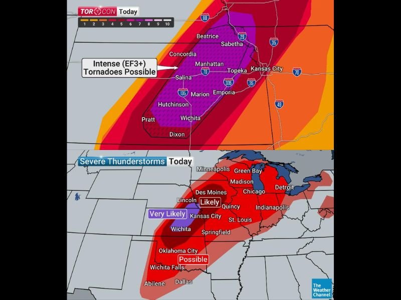
Worst Tornado Day of May With TORCON 7 and EF3 Plus Long Track Tornadoes Targeting Nebraska Kansas and Missouri Including Omaha Wichita Kansas City and Topeka Monday
NEBRASKA — Today, Monday May 18, 2026, is shaping up to be the worst tornado day of May so far following 22 confirmed tornadoes Sunday, with TORCON 7 values and intense EF3-plus long-track tornadoes possible from Michigan to Texas. The most concentrated danger zone runs from near Omaha, Nebraska southward through Wichita, Kansas where discrete supercells will fire this afternoon producing softball size hail and violent tornadoes before the system transitions into a hurricane-force squall line after dark. Have your action plan ready before storms arrive this afternoon.
Discrete Supercells Fire This Afternoon Producing Softball Hail and Violent Tornadoes
Storms begin by afternoon as numerous discrete supercells develop and quickly produce large to potentially softball size hail alongside tornadoes across the primary risk corridor. This initial supercell phase lasting several hours represents the most dangerous tornado window of the entire event for communities from Omaha through Lincoln, Topeka, Manhattan, Wichita, and Kansas City.
EF3-plus long-track tornadoes are explicitly possible during this phase, and anyone in the path of a warned storm must be underground or in an interior lowest-floor room immediately.
System Transitions to Hurricane Force Squall Line After Dark With Embedded Tornadoes
As evening progresses the entire system transitions into a large squall line with damaging winds reaching hurricane force and small embedded tornadoes remaining possible through the overnight hours. This nocturnal phase is particularly dangerous as most residents will be asleep when the squall line arrives across the region.
Avoid sleeping on upper floors if large trees surround your home tonight, and keep weather alerts active through the entire overnight period.
Tornado Risk Extends From Michigan Through Texas With Very Likely Classification Near Kansas City
The broader tornado threat extends from Michigan southward through Iowa, Missouri, Illinois, and into Oklahoma City and Dallas with varying probability levels. The Kansas City corridor carries a Very Likely tornado classification while areas from Des Moines through Chicago are rated Likely, extending this dangerous outbreak across an enormous geographic footprint.
Get into your safe place now — storm shelters, basements, and interior first-floor rooms are your best protection options today. Stay with NapervilleLocal.com for the latest weather updates and local forecast coverage.

I’ve lived in Naperville long enough to see how quickly our community changes — from new developments downtown to sudden shifts in our Midwest weather. Reporting on Naperville news and daily forecasts gives me the chance to keep neighbors informed about what really matters. My goal is simple: deliver clear, timely updates so you always know what’s happening in our city and what to expect from the skies above.