
Major Flooding Risk Developing Across Houston and Southeast Texas With 5 to 7 Inches of Rain Possible Through May 25 as Soggy Week Long Pattern Takes Hold
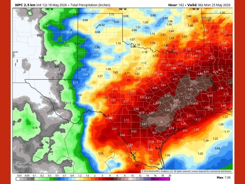
HOUSTON — Houston and Southeast Texas are facing a potentially significant flooding situation as a much wetter pattern takes hold following Monday and is expected to persist for at least a week or longer. The WPC total precipitation forecast valid through May 25 shows staggering rainfall totals of 5 to 7 inches across the Houston metro corridor, with isolated areas potentially seeing even higher amounts. Forecasters are closely monitoring the situation for a possible Stage 1 flood alert as confidence in the heavy rainfall pattern continues to build.
WPC Forecast Shows 5 to 7 Inch Rainfall Totals Across Houston Metro Through May 25
The precipitation forecast map shows the heaviest rainfall totals concentrated across Southeast Texas and the Houston corridor, with deep red and brown colors indicating 5 to 7-plus inch totals valid through the morning of May 25. The maximum forecast value on the map reaches 7.09 inches, placing portions of the greater Houston area at serious flood risk if these totals verify over the coming week.
Surrounding areas including Beaumont, Conroe, and the Gulf Coast corridor are also showing 3 to 5 inch totals across the broader rainfall footprint.
Stage 1 Flood Alert Being Monitored as Wet Pattern Expected to Persist for a Week or Longer
Forecasters are holding off on issuing a Stage 1 flood alert for now but are watching the situation closely as the wet pattern is expected to persist for at least a week. The extended duration of the rainfall threat is what makes this setup particularly concerning, as repeated rounds of heavy rain over the same saturated ground dramatically increases flooding potential across low-lying areas. Residents across Houston and Southeast Texas should monitor flood watches and warnings closely through the coming week.
Houston Residents Should Prepare Now for Extended Period of Heavy Rainfall and Flooding
With a soggy week-long pattern setting up across Southeast Texas, Houston residents should take proactive steps now before conditions deteriorate. Clearing drains, avoiding flood-prone roadways, and monitoring real-time rainfall totals will be essential through the May 25 timeframe.
Never attempt to drive through flooded roadways regardless of how shallow the water appears, as just inches of moving water can sweep vehicles off roadways. Stay with NapervilleLocal.com for the latest weather updates and local forecast coverage.

I’ve lived in Naperville long enough to see how quickly our community changes — from new developments downtown to sudden shifts in our Midwest weather. Reporting on Naperville news and daily forecasts gives me the chance to keep neighbors informed about what really matters. My goal is simple: deliver clear, timely updates so you always know what’s happening in our city and what to expect from the skies above.