
Damaging Winds Large Hail Heavy Rain and Brief Tornado Possible Across Indiana With Squall Line Arriving Between 11AM and 1PM Monday May 18
INDIANA — A Slight Risk severe weather setup is taking shape across Indiana Monday, May 18, 2026, with a squall line expected to enter the state between 11 AM and 1 PM and continue through the evening hours. Damaging winds, heavy rain, large hail, and localized flooding are the primary hazards, with a brief tornado or two unable to be ruled out as the afternoon unfolds. The SPC has already expanded the Slight Risk farther south and east than yesterday’s outlook with additional updates possible through the morning.
Squall Line Arrives Between 11AM and 1PM With Damaging Winds and Heavy Rain
Model guidance strongly suggests today’s event behaves as a classic squall line, bringing a fast-moving line of storms into Indiana during the late morning and early afternoon hours. Damaging winds are the primary concern with a squall line event of this nature, capable of causing widespread tree damage, power outages, and structural damage across the state.
Heavy rain and localized flooding are also significant concerns as the storm system pushes through Indiana during the afternoon and evening hours.
Large Hail and Brief Tornado Cannot Be Ruled Out During Afternoon Hours
Alongside the dominant wind and rain threats, large hail and a brief tornado or two remain possible as the squall line moves through Indiana Monday afternoon. The Slight Risk designation covering the majority of the state confirms that severe weather is a real and meaningful threat rather than a marginal one for today’s event. Residents across Indiana should have multiple reliable ways to receive warnings active before the 11 AM storm arrival window.
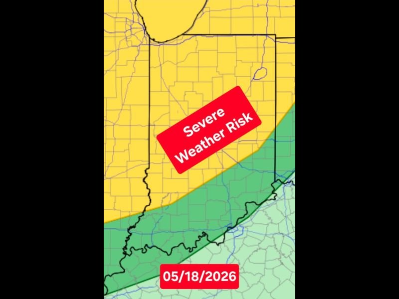
Slight Risk Covers Most of Indiana With Further Upgrades Possible This Morning
The yellow Slight Risk zone covers the vast majority of Indiana on Monday’s outlook, with the SPC having already expanded coverage farther south and east than initially anticipated. Additional upgrades to the outlook remain possible through the morning hours as forecasters continue analyzing the evolving storm setup.
Have a shelter plan confirmed and weather alerts active well before 11 AM — knowing exactly where you will go if a warning is issued is the most important preparation step for today. Stay with NapervilleLocal.com for the latest weather updates and local forecast coverage.

I’ve lived in Naperville long enough to see how quickly our community changes — from new developments downtown to sudden shifts in our Midwest weather. Reporting on Naperville news and daily forecasts gives me the chance to keep neighbors informed about what really matters. My goal is simple: deliver clear, timely updates so you always know what’s happening in our city and what to expect from the skies above.