
Cold Temps Snow Showers and Gusty Winds Across Colorado Wyoming and Plains Including Denver Front Range and Eastern Nebraska With Active Pattern Continuing Through the Week
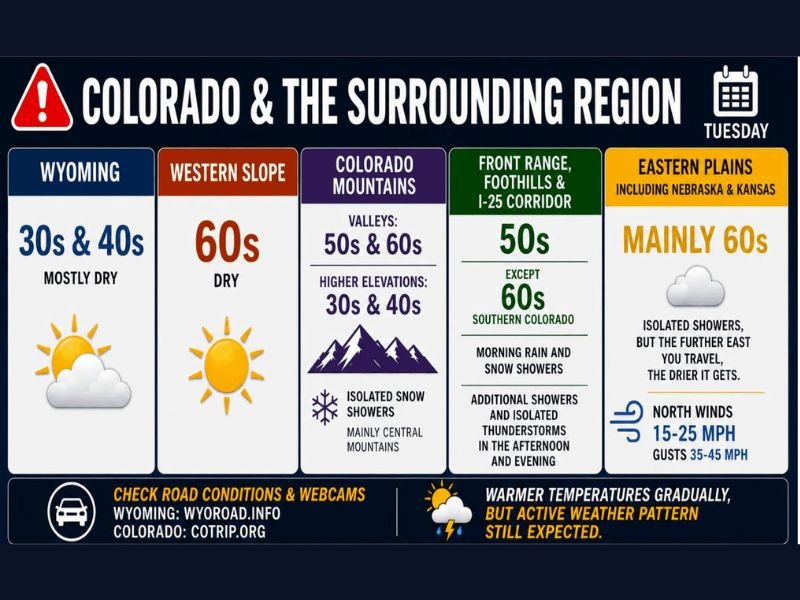
COLORADO — In the wake of Monday’s departing storm system, a dramatically different and much cooler Tuesday is unfolding across Colorado, Wyoming, and the surrounding region. Wyoming sits in the cold 30s and 40s while the Front Range and I-25 corridor deals with 50s, morning rain and snow showers, and additional afternoon thunderstorms. The eastern plains including Nebraska and Kansas face gusty north winds of 35 to 45 mph making east-west travel on I-80, I-76, and I-70 dangerous through the day.
Wyoming Cold in the 30s and 40s While Western Slope Enjoys Sunny 60s
Wyoming is cold and mostly dry Tuesday in the 30s and 40s following significant snowfall from Monday’s storm system. The western slope is the pleasant outlier on the regional map, sitting in the sunny 60s and dry conditions — a stark contrast to the rest of the region.
Colorado mountain valleys sit in the 50s and 60s with higher elevations dropping into the 30s and 40s alongside isolated snow showers mainly in the central mountains.
Front Range and I-25 Corridor Sees Morning Snow Showers and Afternoon Thunderstorms
The Front Range, foothills, and I-25 corridor start Tuesday with morning rain and snow showers before transitioning to additional showers and isolated thunderstorms through the afternoon and evening. Temperatures sit in the 50s across most of the corridor with southern Colorado reaching into the 60s.
Travel along the Front Range and mountain passes should be approached with caution through Tuesday given the mix of precipitation types through the day.
Eastern Plains Face 35 to 45mph Gusts With Dangerous Travel on I-80 I-76 and I-70
The eastern plains including Nebraska and Kansas sit in the mainly 60s Tuesday but face gusty north winds of 15 to 25 mph with gusts reaching 35 to 45 mph as the departing storm system pulls away to the east. Drivers traveling major east-west routes including I-80, I-76, I-70, Highway 34, and Highway 50 should use extreme caution given the dangerous crosswind potential through the day.
Scattered showers and thunderstorms continue Wednesday and Thursday as the active weather pattern persists despite gradually warming temperatures through the rest of the week. Stay with NapervilleLocal.com for the latest weather updates and local forecast coverage.

I’ve lived in Naperville long enough to see how quickly our community changes — from new developments downtown to sudden shifts in our Midwest weather. Reporting on Naperville news and daily forecasts gives me the chance to keep neighbors informed about what really matters. My goal is simple: deliver clear, timely updates so you always know what’s happening in our city and what to expect from the skies above.