
Heavy Rain, Thunder, and Lightning Main Event Targeting North Georgia and Western Carolinas Including Atlanta, Asheville, and Greenville With Peak Storm Sunday Night
NORTH GEORGIA AND WESTERN CAROLINAS — A significant overnight storm event is on the way for north Georgia and the western Carolinas on Sunday, May 24, 2026, with high resolution models advertising the main round of heavy rain, thunder, and lightning arriving between 8PM and 1AM. Scattered storms are possible through the afternoon offering some dry time before conditions deteriorate sharply tonight as the main event pushes through the Knoxville, Asheville, Atlanta, and Greenville corridors.
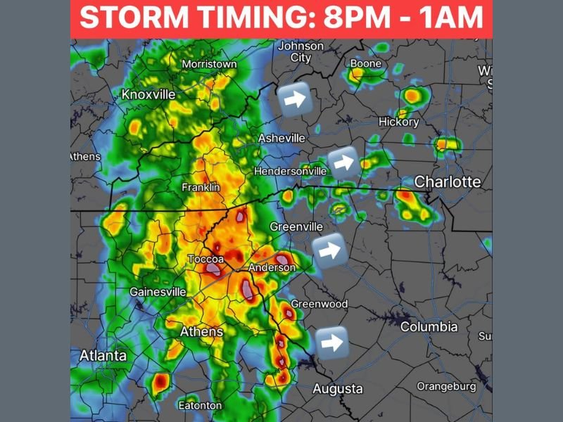
Main Storm Event Arrives 8PM to 1AM With Heavy Rain and Lightning Across the Region
High resolution model guidance is consistent in timing the primary and most impactful storm round between 8PM and 1AM Sunday night across the north Georgia and western Carolinas corridor. The futuretrack radar simulation shows intense red and yellow cores blanketing a wide zone from Knoxville and Franklin through Toccoa, Athens, and Atlanta with heavy storm activity pushing eastward toward Greenville and Anderson.
If the system holds together through the afternoon and evening as modeled, residents across the entire corridor should expect heavy rainfall rates, frequent lightning, and loud thunder during the 8PM to 1AM window. This is the event to prepare for heading into Sunday evening.
Atlanta, Toccoa, and Athens Corridor Facing the Most Intense Storm Coverage Tonight
The most intense storm signatures on the model simulation are concentrated across the north Georgia corridor including Gainesville, Toccoa, Athens, and Atlanta, where deep red cores indicate the heaviest rainfall rates within the system. The storm coverage across this zone is dense and widespread rather than isolated, suggesting most communities in the corridor will experience significant impacts during the overnight window.
Residents across the Atlanta metro and surrounding north Georgia communities should secure any outdoor items before evening arrives and plan to remain indoors during the 8PM to 1AM period. Flash flooding remains a concern across areas that have already received heavy rainfall earlier in the weekend.
Storms Tracking Eastward Toward Greenville, Anderson, and Charlotte Through the Night
The storm system is tracking eastward as indicated by the movement arrows on the simulation, pushing the heavy rain and lightning threat toward Greenville, Anderson, Greenwood, and eventually toward Charlotte through the overnight hours. Communities across Upstate South Carolina should anticipate the main event arriving later in the window as the system progresses eastward from the Georgia core.
More rounds of storms are expected through the coming week as the active pattern continues across the region. Staying connected to local weather alerts through Sunday night and into the week ahead is strongly recommended for all residents across the north Georgia and western Carolinas corridor. Stay with NapervilleLocal.com for the latest weather updates and local forecast coverage.

I’ve lived in Naperville long enough to see how quickly our community changes — from new developments downtown to sudden shifts in our Midwest weather. Reporting on Naperville news and daily forecasts gives me the chance to keep neighbors informed about what really matters. My goal is simple: deliver clear, timely updates so you always know what’s happening in our city and what to expect from the skies above.