
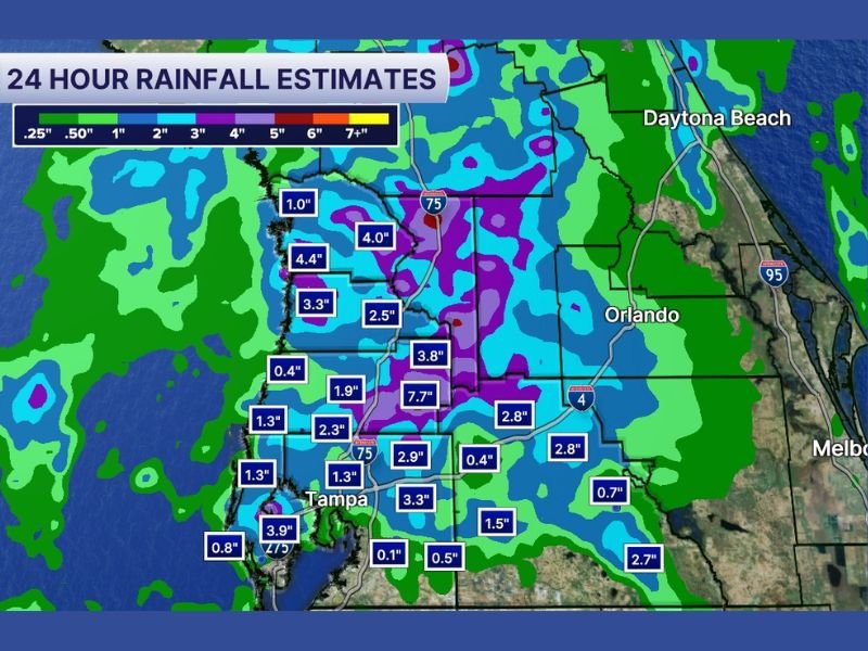
Heavy 24-Hour Rainfall Totals Up to 7 Inches Concentrated Along the I-4 Corridor and North With Southern Areas From St Pete Through Sarasota Still Awaiting Heaviest Rain Sunday
TAMPA BAY AND CENTRAL FLORIDA — Heavy rainfall over the past 24 hours has dropped significant totals across the Tampa Bay and Central Florida region, with the heaviest accumulations concentrated along the I-4 corridor and points north. The 24-hour rainfall estimate map shows totals ranging from a quarter inch across drier southern zones to 7.7 inches in the highest recorded pocket near the I-4 corridor, while southern areas from downtown St. Pete through Ruskin, Fort Meade, Sarasota, and Bradenton received little to no rainfall and are still awaiting their heaviest rain later today.
I-4 Corridor and Northern Zones Bearing the Brunt of 24-Hour Rainfall Totals
The I-4 corridor and areas to the north recorded the most significant rainfall totals over the past 24 hours, with the highest single estimate reaching 7.7 inches in a concentrated pocket just north of Tampa near the interstate. Surrounding areas recorded totals of 3.8, 4.0, and 4.4 inches across the broader northern zone, with additional readings of 2.5 to 3.3 inches common across much of the central corridor.
Areas near Orlando and the I-95 corridor to the east recorded totals of 2.8 inches, while Daytona Beach and the northeastern portions of the map saw lighter accumulations in the 1 to 2 inch range. The purple signature on the rainfall estimate map centered near the I-4 corridor clearly identifies this zone as the focal point of the heaviest 24-hour rainfall activity.
Tampa Metro Seeing Uneven Rainfall Distribution From North to South
The Tampa metro area itself shows a stark north-to-south contrast in rainfall totals over the past 24 hours. Northern and central portions of the metro recorded totals of 1.9 to 3.9 inches, while areas closer to downtown Tampa and points south received only 0.1 to 0.5 inches across the same period.
This uneven distribution highlights the localized and training nature of the storm activity that has impacted the region, with some neighborhoods seeing significant accumulation while others just miles away stayed nearly dry. Residents across the southern metro zones should remain prepared for heavier rainfall to arrive later today as the pattern shifts southward.
Southern Zones From St Pete Through Sarasota and Bradenton Still Awaiting Heavy Rain
The southern portions of the Tampa Bay region including downtown St. Pete, Ruskin, Fort Meade, Sarasota, and Bradenton recorded minimal rainfall through Sunday morning, with totals as low as 0.1 to 0.8 inches across these communities. Forecasters are hopeful that the heaviest rain will shift toward these southern areas later today as the rainfall pattern evolves through the afternoon.
Residents across the southern zones who have largely avoided significant rainfall so far should not consider themselves out of the weather picture for Sunday. The heaviest and most impactful rain for these communities may still be ahead later today as storm activity pushes southward across the region. Stay with NapervilleLocal.com for the latest weather updates and local forecast coverage.

I’ve lived in Naperville long enough to see how quickly our community changes — from new developments downtown to sudden shifts in our Midwest weather. Reporting on Naperville news and daily forecasts gives me the chance to keep neighbors informed about what really matters. My goal is simple: deliver clear, timely updates so you always know what’s happening in our city and what to expect from the skies above.