
Heavy Downpours Hitting Horry County and the Grand Strand Including Myrtle Beach and North Myrtle Beach With Storm Chances Shifting West Toward Pee Dee and Border Belt by Early Afternoon Sunday
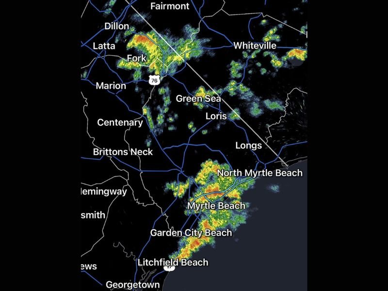
HORRY COUNTY AND THE GRAND STRAND — Heavy downpours are concentrated across parts of Horry County and the Grand Strand coastline Sunday morning, May 24, 2026, with radar at 9:10AM showing intense storm cores pushing through Myrtle Beach, North Myrtle Beach, Garden City Beach, and Litchfield Beach. Carolina Forest has already recorded 1.25 inches of rain through the morning hours, and the feast or famine nature of this storm pattern means some communities are seeing significant rainfall while others nearby remain completely dry.
Heavy Downpours Concentrated Across Horry County and the Coastal Grand Strand This Morning
Radar at 9:10AM shows the heaviest storm activity concentrated along the Grand Strand coastline, with intense red and yellow cores pushing through Myrtle Beach, North Myrtle Beach, and Garden City Beach Sunday morning. A separate band of moderate to heavy activity is also present across the northern zones near Dillon, Latta, Fork, and extending toward Whiteville.
The feast or famine rainfall distribution is clearly evident on radar, with some communities directly under heavy cores receiving significant rainfall while others just a few miles away remain completely dry. Residents across Horry County and the immediate coastal zones are experiencing the most active morning conditions of the broader region.
Storm Activity Expected to Gradually Shift West Toward Pee Dee and Border Belt by Early Afternoon
The best chances for showers and storms will gradually shift westward toward the Pee Dee and Border Belt regions by early afternoon as the morning coastal activity begins to evolve. Communities including Marion, Centenary, Hemingway, and Brittons Neck will see increasing storm chances as the coverage migrates inland through the midday hours.
This westward shift will bring much-needed rainfall to interior communities that have seen little to no precipitation through the morning hours. However, the scattered and uneven nature of the coverage means not every location in the Pee Dee and Border Belt zones will receive meaningful rainfall even as the pattern shifts in their direction.
Localized Heavy Rain Remains Possible as Feast or Famine Pattern Continues Through the Day
The feast or famine nature of today’s storm coverage means localized heavy rainfall and ponding remain possible wherever the most intense cells develop through the afternoon. Communities from Loris and Green Sea through Longs and the broader Horry County interior should remain aware of rapidly changing conditions as storm activity evolves through the day.
Staying connected to local radar updates will be the most valuable tool for residents trying to anticipate when and where the heaviest rainfall will impact their specific community on Sunday. Anyone near flood-prone areas or low-lying roadways should remain cautious through the afternoon as the storm pattern continues shifting across the region. Stay with NapervilleLocal.com for the latest weather updates and local forecast coverage.

I’ve lived in Naperville long enough to see how quickly our community changes — from new developments downtown to sudden shifts in our Midwest weather. Reporting on Naperville news and daily forecasts gives me the chance to keep neighbors informed about what really matters. My goal is simple: deliver clear, timely updates so you always know what’s happening in our city and what to expect from the skies above.