
Strong to Severe Storms With Large Hail, Damaging Winds to 60 MPH, and Isolated Tornado Possible Across Southeast Wyoming, Northeast Colorado, and Western Nebraska Friday
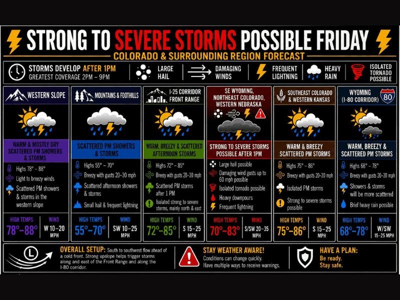
COLORADO AND SURROUNDING REGION — Strong to severe thunderstorms are possible across Colorado and the surrounding region on Friday, May 29, 2026, with storms developing after 1PM and greatest coverage expected between 2PM and 9PM. The highest threat zone covers southeast Wyoming, northeast Colorado, and western Nebraska where large hail, damaging wind gusts up to 60 mph, an isolated tornado, heavy downpours, and frequent lightning are all on the table with all modes of severe weather possible for those who do get hit.
SE Wyoming, Northeast Colorado, and Western Nebraska Carrying the Highest Severe Risk
The primary severe weather zone Friday runs across southeast Wyoming, the I-76 corridor, northeast Colorado, and the western Nebraska Panhandle, where strong to severe storms capable of all hazard modes are possible after 1PM. Large hail is the highest probability hazard, but damaging wind gusts to 60 mph and an isolated tornado cannot be ruled out across this corridor.
Highs in this zone will reach 70 to 83 degrees with south to southwest winds of 20 to 35 mph providing the directional shear needed to support organized and rotating storm structures through the afternoon.
Front Range and I-25 Corridor Seeing Warm Breezy Conditions With Afternoon Storm Chances
The Front Range and I-25 corridor will be warm and breezy with highs reaching 72 to 85 degrees and southwest winds of 15 to 25 mph. Isolated strong to severe storms are possible after 1PM mainly north and east of the corridor, with small hail and frequent lightning as the primary concerns for the Denver metro and surrounding communities.
Mountains and foothills will see scattered PM showers and storms with small hail and frequent lightning, highs of 55 to 70 degrees, and breezy conditions with gusts to 20 to 30 mph.
Saturday Brings Another Round Focused North of I-70 and North of I-76 Into Northeast Plains
Saturday shifts the severe focus northward with strong to severe storm potential north of I-70 in the mountains and north of I-76 across the northern Front Range and northeast plains. The active pattern continues into next week with no two days looking exactly alike across the region. Stay with NapervilleLocal.com for the latest weather updates and local forecast coverage.

I’ve lived in Naperville long enough to see how quickly our community changes — from new developments downtown to sudden shifts in our Midwest weather. Reporting on Naperville news and daily forecasts gives me the chance to keep neighbors informed about what really matters. My goal is simple: deliver clear, timely updates so you always know what’s happening in our city and what to expect from the skies above.