
Significant Cooldown of 5 to 11 Degrees Below Normal Arriving Across the Carolinas and North Georgia Including Greenville, Asheville, and Spartanburg From Sunday Through Wednesday
WESTERN CAROLINAS AND NORTH GEORGIA — A welcome and significant cooldown is arriving across the western Carolinas and north Georgia beginning Sunday evening, May 31, 2026, as drier air filters into the region and pushes temperatures 5 to 11 degrees below normal through Wednesday.
After weeks of relentless humidity and tropical downpours, the pattern shift will bring cool nights with 40s in the mountains and 50s across much of the Upstate, offering meaningful relief for a region that has been enduring persistently warm and oppressively humid conditions.
Temperatures Dropping 10 to 11 Degrees Below Normal Across the Upstate Corridor
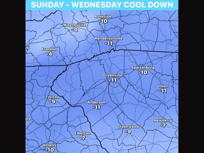
The Sunday through Wednesday cool down departure map shows the most dramatic below normal temperature anomalies concentrated across the Upstate South Carolina and western North Carolina corridor. Greenville, Hendersonville, Anderson, and Union all show departures of 11 degrees below normal, while Spartanburg sits at 10 degrees below normal and Asheville also drops 10 degrees below its seasonal average.
These anomalies represent a substantial and noticeable pattern change that will make outdoor conditions feel dramatically different from the humid and warm stretch that has dominated the region through the recent weeks of active weather.
Mountain Communities and Foothills Seeing Chilly Below Normal Nights Through the Period
Mountain and foothill communities will experience some of the most noticeably cool overnight temperatures during the Sunday through Wednesday period, with mountain lows dropping into the 40s and Upstate communities seeing widespread 50s through multiple nights. These temperatures are quite chilly by early June standards and will feel especially refreshing following the humid tropical moisture pattern.
Waynesville and Franklin will see departures of 4 degrees below normal while Toccoa sits at 9 and Athens drops 10 degrees below seasonal averages through the cool period.
Drier Air and Below Normal Temperatures Bringing Welcome Relief After Recent Wet Pattern
The arrival of drier air alongside the below normal temperatures is perhaps the most welcome aspect of the upcoming pattern change for residents across the region. The combination of lower humidity and cooler temperatures will make outdoor conditions significantly more comfortable through the midweek period before the pattern eventually moderates heading toward the following weekend. Stay with NapervilleLocal.com for the latest weather updates and local forecast coverage.

I’ve lived in Naperville long enough to see how quickly our community changes — from new developments downtown to sudden shifts in our Midwest weather. Reporting on Naperville news and daily forecasts gives me the chance to keep neighbors informed about what really matters. My goal is simple: deliver clear, timely updates so you always know what’s happening in our city and what to expect from the skies above.