
Massive African Dust Plumes Reaching the Gulf of Mexico and Wrapping Toward the Southeast and Florida Through the Weekend Drying Out Coastal Rain Forecasts
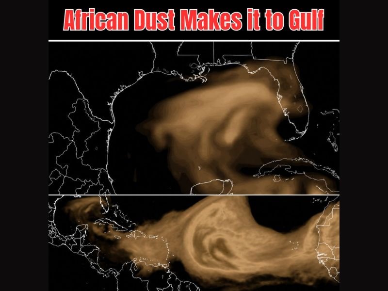
GULF COAST AND SOUTHEAST UNITED STATES — Large plumes of African dust have successfully crossed the Atlantic Ocean and reached the Gulf of Mexico, with satellite imagery showing a massive and dense dust layer wrapping northward through the Gulf before curling back toward the Southeast and Florida through the weekend. A second even larger plume is visible trailing behind the first across the Atlantic, signaling that the dust event will be prolonged and impactful across the region. The dust intrusion is playing a meaningful role in drying out coastal rain forecasts while setting the stage for spectacular sunsets across the Gulf Coast and Southeast.
Massive Dust Plumes Crossing the Atlantic and Reaching the Gulf of Mexico
Satellite imagery clearly shows the dense African dust plume blanketing a broad zone across the Gulf of Mexico, with the thick brown aerosol layer visible from the Caribbean northward toward the Gulf Coast states. The scale of the dust transport is remarkable, with the plume stretching across thousands of miles from the African continent to the Gulf in a single continuous layer.
A second and even larger dust plume is visible in the trailing satellite frame positioned over the Atlantic and Caribbean, indicating that additional dust suppression impacts are on the way for the region beyond the current event already affecting the Gulf.
Dust Wrapping Toward Southeast and Florida Through the Weekend Drying Coastal Forecasts
The dust circulation is wrapping northward through the Gulf and then curling back toward the Southeast and Florida coastline through the weekend period. This dry and dust-laden air mass is actively suppressing moisture and reducing coastal rain chances across the affected zones, helping to dry out what had been persistently wet and humid conditions along the Gulf and Florida coasts in recent weeks.
The drying effect of the Saharan Air Layer associated with these dust plumes is a well-documented phenomenon that can significantly reduce tropical storm development potential while also cutting into rainfall coverage.
Spectacular Sunsets Expected Across the Gulf Coast and Southeast This Weekend
One of the most visually striking side effects of African dust intrusions is the dramatically enhanced sunset colors produced as sunlight scatters through the thick aerosol layer. Residents across the Gulf Coast, Southeast, and Florida should look for vivid orange, red, and pink sunset displays through the weekend as the dust continues moving through the region. Stay with NapervilleLocal.com for the latest weather updates and local forecast coverage.

I’ve lived in Naperville long enough to see how quickly our community changes — from new developments downtown to sudden shifts in our Midwest weather. Reporting on Naperville news and daily forecasts gives me the chance to keep neighbors informed about what really matters. My goal is simple: deliver clear, timely updates so you always know what’s happening in our city and what to expect from the skies above.