
Cool Front Delivering Fall-Like Dry Conditions Across the Southeast Including Georgia Tennessee and the Carolinas While Gulf Moisture Stays Contained Through the Weekend
SOUTHEASTERN UNITED STATES — A cool front is sneaking into the South this week, delivering a rare taste of fall-like air across the Southeast including Georgia, Tennessee, and the Carolinas while leaving behind a Gulf moisture blob that is expected to remain mostly contained over the Gulf of Mexico through Friday night.
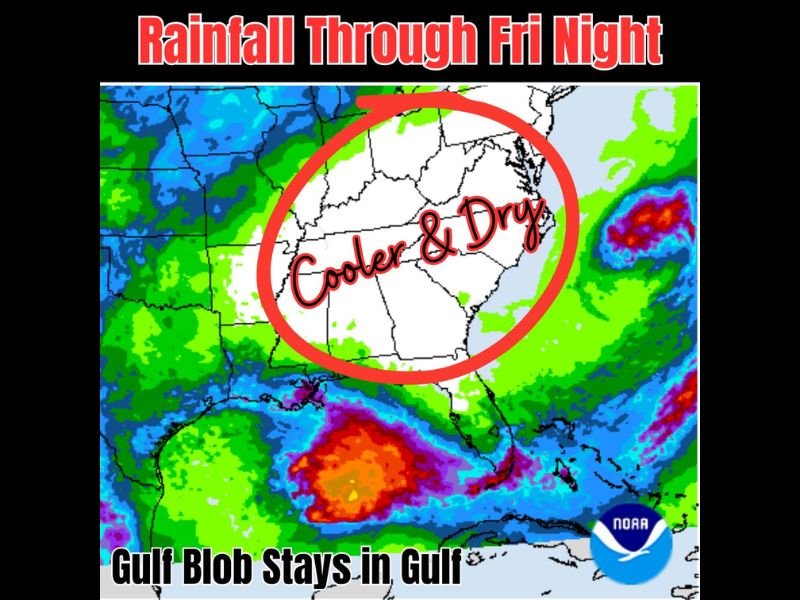
The NOAA precipitation map clearly shows a large dry and cool pocket circled across the interior Southeast, contrasting sharply with the heavy rainfall depicted in green, orange, and red surrounding the region on all sides. The cooler and drier pattern is forecast to last for several days and carry into the weekend for many communities across the affected zone.
Cool and Dry Air Settles Across Georgia Tennessee and the Carolinas Through the Weekend
The interior Southeast from Tennessee southward through Georgia and across both Carolinas sits inside the notable dry zone on the precipitation map, with little to no rainfall accumulation expected through Friday night. Cooler and drier air behind the front will produce a genuine fall-like feel across this region, a welcome and unusual break from the heat and humidity typical of early June. The dry and comfortable pattern is expected to hold for most communities through at least the weekend before the summer pattern gradually reasserts itself.
Gulf Moisture Blob Stays Mostly Contained Over the Gulf Through Friday Night
The most important aspect of this forecast is the Gulf moisture disturbance remaining largely confined over the Gulf of Mexico rather than pushing significant rainfall northward into the Southeast. The precipitation map shows intense orange and red moisture accumulations positioned over the northern Gulf and southern Florida, but the cool and dry air mass over the interior Southeast is acting as a barrier keeping that moisture from advancing. Rainfall totals through Friday night will be minimal across the circled dry zone compared to the heavy totals surrounding it.
Surrounding Areas See Active Rainfall While the Southeast Stays Quiet
While the interior Southeast enjoys dry conditions, surrounding areas including the Gulf Coast, Florida, and portions of the Mid-Atlantic are seeing active rainfall depicted in the green and purple shading on the map. The contrast between the dry Southeast pocket and the active moisture surrounding it on three sides makes this pattern particularly noteworthy for early June. Residents across the cooler and drier zone should take full advantage of the comfortable conditions before summer heat and humidity return.
Stay with NapervilleLocal.com for the latest weather updates and local forecast coverage.

I’ve lived in Naperville long enough to see how quickly our community changes — from new developments downtown to sudden shifts in our Midwest weather. Reporting on Naperville news and daily forecasts gives me the chance to keep neighbors informed about what really matters. My goal is simple: deliver clear, timely updates so you always know what’s happening in our city and what to expect from the skies above.