
Hen-Egg Size Hail and Organized Severe Storms Targeting Omaha Sioux Falls Des Moines Kansas City and Western Wisconsin With Level 2 and 3 Risk Friday June 5th
CENTRAL PLAINS INTO THE UPPER MIDWEST — A significant severe weather setup is on the map for Friday June 5th, with a Level 2 and embedded Level 3 risk zone stretching from Omaha northward through Sioux Falls and eastward toward western Wisconsin, carrying enough atmospheric fuel for organized severe storms with hen-egg size hail as the primary threat.
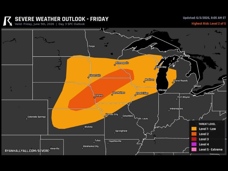
The SPC Day 3 outlook updated Wednesday June 3rd shows the deeper red Level 3 zone concentrated over the Omaha to Sioux Falls corridor, sitting inside a broader orange Level 2 zone that expands through Des Moines, Kansas City, Minneapolis, Madison, and the Quad Cities. The atmosphere has sufficient instability and shear to support a few well-organized severe storm structures across this region Friday.
Level 3 Risk Zone Concentrated From Omaha Through Sioux Falls
The highest risk area on the Friday outlook is the red Level 3 zone positioned over the Omaha to Sioux Falls corridor, where atmospheric parameters are most favorable for organized supercell development capable of producing the largest hail. Hen-egg size hail is the headline threat within this zone, representing stones large enough to cause serious damage to vehicles, rooftops, skylights, and any exposed property. Residents across Nebraska, South Dakota, and western Iowa within the Level 3 footprint should be making preparation plans now ahead of Friday’s arrival.
Broader Level 2 Zone Covers Minneapolis Des Moines Kansas City and Quad Cities
The wider orange Level 2 zone extends the organized severe storm threat across a large swath of the central plains and upper Midwest, putting Minneapolis, Des Moines, Kansas City, Madison, and the Quad Cities all within range of significant severe weather Friday. Large hail remains the primary concern across the full Level 2 area, though damaging winds cannot be ruled out with the strongest storm cells. The Level 1 low-risk zone pushes the overall threat footprint even further outward toward Chicago and Columbia.
Friday Plans Across the Entire Risk Zone Need a Weather Safety Component
With a multi-day heads up on this setup, residents across the full risk corridor from Kansas City through Omaha, Sioux Falls, Des Moines, and western Wisconsin have time to prepare now. Securing vehicles under cover Friday and having a shelter plan in place before afternoon storm development begins are the two most important preparation steps. Monitor the outlook closely through Thursday as the forecast confidence and risk levels may be upgraded further as the event approaches.
Stay with NapervilleLocal.com for the latest weather updates and local forecast coverage.

I’ve lived in Naperville long enough to see how quickly our community changes — from new developments downtown to sudden shifts in our Midwest weather. Reporting on Naperville news and daily forecasts gives me the chance to keep neighbors informed about what really matters. My goal is simple: deliver clear, timely updates so you always know what’s happening in our city and what to expect from the skies above.