
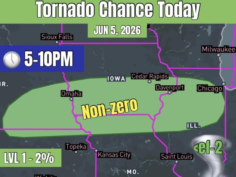
Non-Zero Brief Tornado Chance Across Eastern Nebraska Iowa and Northern Illinois Including Omaha Cedar Rapids Davenport and Chicago Between 5 and 10 PM Friday June 5th
EASTERN NEBRASKA INTO NORTHERN ILLINOIS — A non-zero tornado chance exists across a broad corridor stretching from eastern Nebraska through Iowa and into northern Illinois Friday June 5th, with the threat window running from 5 PM through 10 PM. The Level 1 two percent tornado probability zone covers a large footprint including Omaha, Cedar Rapids, Davenport, and extends eastward toward Chicago and the northern Illinois border.
Any tornadoes that develop are expected to remain below EF-2 intensity, and most guidance suggests storms may not even form. However, enough atmospheric ingredients are present that a brief tornado or two cannot be ruled out.
Low But Non-Zero Tornado Chance Supported by Weak but Sufficient Shear
The tornado setup is characterized by weak but sufficient wind shear to support brief tornado development if a couple of storms manage to fire across the risk corridor. Forecasters are clear that this is a low-probability scenario and most model guidance leans toward limited storm development across the zone.
Despite the low odds, the shear environment is just robust enough that any storm that does organize could briefly produce a tornado before weakening. A chance is a chance regardless of how low the probability sits.
Risk Zone Stretches From Omaha Through Iowa Into Northern Illinois
The green tornado probability zone on the Friday June 5th outlook map covers eastern Nebraska from the Omaha corridor northeastward across the full width of Iowa through Cedar Rapids and Davenport, then extending into northern Illinois approaching the Chicago metro area. Communities across this entire corridor carry the Level 1 two percent tornado probability through the 5 to 10 PM window.
Southern portions of the risk zone extend toward Topeka and Kansas City, though the primary tornado corridor sits along and north of the Iowa state line.
Monitor Conditions Closely Between 5 and 10 PM Across the Entire Risk Zone
Residents across eastern Nebraska, Iowa, and northern Illinois should have a way to receive severe weather warnings readily available Friday evening between 5 and 10 PM. Even a low-probability tornado threat warrants awareness given how quickly storm conditions can change during the evening hours. Stay weather-aware and do not dismiss the risk simply because overall storm chances remain uncertain. Stay with NapervilleLocal.com for the latest weather updates and local forecast coverage.

I’ve lived in Naperville long enough to see how quickly our community changes — from new developments downtown to sudden shifts in our Midwest weather. Reporting on Naperville news and daily forecasts gives me the chance to keep neighbors informed about what really matters. My goal is simple: deliver clear, timely updates so you always know what’s happening in our city and what to expect from the skies above.