
Tropical Low Pressure System Possible Late Next Week as EURO and GFS Models Show Gulf and Caribbean Development Around June 13th to 14th
GULF OF MEXICO AND CARIBBEAN — Tropical weather watchers are monitoring a growing signal in both the EURO and GFS ensemble models for a low pressure system to develop out of Central America and the western Caribbean late next week, with valid times showing the feature positioned over the Gulf and Caribbean region around June 13th to 14th. Most ensemble members are clustering in the 1000 millibar range, suggesting the system would be more consistent with a Tropical Depression or Tropical Storm rather than a stronger hurricane-level threat if development occurs.
Whether the system becomes organized or not remains uncertain, but the signal is slightly stronger than it was 24 hours ago with a few more ensemble members coming on board.
EURO and GFS Both Depicting Low Pressure Developing From Central America Late Next Week
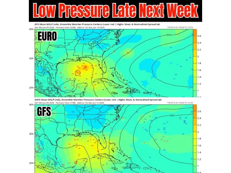
The EURO ensemble mean valid Sunday June 14th shows a concentrated area of low pressure centers clustered over the western Gulf and northwestern Caribbean, with the tightest ensemble clustering located near the Yucatan Peninsula region. The GFS ensemble valid Saturday June 13th shows a similar but slightly less organized signal with low pressure members spread across the western Gulf and Central American coast.
Both models are in general agreement that moisture and energy pulling northward out of Central America is the source of this potential development, though track and intensity remain highly uncertain at this extended range.
System Remains Tropical Depression or Tropical Storm Potential at This Stage
The 1000 millibar pressure readings across the ensemble members indicate a relatively weak system if development does occur, more consistent with a Tropical Depression or minimal Tropical Storm than any significant hurricane threat. The lack of a tight and organized ensemble cluster at this range reflects the inherent uncertainty in extended tropical forecasting beyond seven to ten days.
No major changes from the previous day’s guidance, but confidence is slowly and incrementally building.
East Side of the System Could Increase Rain Chances the Following Weekend
One notable takeaway from the current ensemble data is that the eastern side of whatever develops could begin increasing rain chances across portions of the Gulf Coast and Southeast during the weekend of June 14th and beyond. Residents across coastal areas should monitor updates through next week as the signal becomes clearer and model confidence either increases or decreases with each new run. Stay with NapervilleLocal.com for the latest weather updates and local forecast coverage.

I’ve lived in Naperville long enough to see how quickly our community changes — from new developments downtown to sudden shifts in our Midwest weather. Reporting on Naperville news and daily forecasts gives me the chance to keep neighbors informed about what really matters. My goal is simple: deliver clear, timely updates so you always know what’s happening in our city and what to expect from the skies above.