
Gulf Low Pressure System to Watch Late Next Week as Models Show Rain and Gusty Winds Possible From Texas to Florida With Too Early for Specifics
GULF COAST — Both the GFS and EURO models are indicating a low pressure system developing in the Gulf of Mexico late next week, though forecasters are stressing this is not a major concern at this time. At most, the system looks like a rain-maker for communities along the Gulf Coast from Texas to Florida, depending on where it forms and how it ultimately tracks.
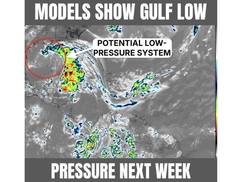
The system appears broad and disorganized on the EURO satellite simulation, suggesting it may be a hybrid system rather than a fully tropical one, with strong upper-level shear limiting its development potential.
EURO Simulation Shows a Broad Disorganized System With Rain Well East of the Center
The EURO satellite simulation clearly depicts a very broad low pressure system with the circulation center circled in red while the heaviest rain and convection are displaced well to the east in a linear arrangement rather than wrapped tightly around the center. This structural signature indicates a system under significant upper-level shear stress, preventing it from organizing into a compact and stronger tropical system.
A hybrid or non-tropical classification at this stage appears most likely based on the current model depictions from both major global models.
Potential Impacts Range From Brownsville Texas to Miami Florida
The current level of forecast uncertainty is high enough that potential impacts could affect anyone from Brownsville Texas to Miami Florida with some combination of rain and gusty winds. The displaced convection sitting well east of the low center could actually benefit Florida by funneling additional rainfall into the state depending on the final track.
It is far too early to make specific plans or draw conclusions about where the heaviest impacts will occur.
Not a Major Concern but Worth Monitoring Through Next Week
Forecasters are being clear that this system does not represent a major threat at this stage of development, and residents along the Gulf Coast should monitor updates through next week rather than making significant preparations now. The track, intensity, and even tropical classification of the system remain highly uncertain at this extended forecast range.
Check back for updates as model guidance becomes more consistent and the forecast window tightens. Stay with NapervilleLocal.com for the latest weather updates and local forecast coverage.

I’ve lived in Naperville long enough to see how quickly our community changes — from new developments downtown to sudden shifts in our Midwest weather. Reporting on Naperville news and daily forecasts gives me the chance to keep neighbors informed about what really matters. My goal is simple: deliver clear, timely updates so you always know what’s happening in our city and what to expect from the skies above.