
Flash Flood Warnings Active Across Central Kentucky Including Louisville Elizabethtown and Lexington With Heavy Rain Spreading Statewide Tuesday Morning
CENTRAL KENTUCKY — Flash Flood Warnings are active across portions of central Kentucky Tuesday morning as heavy rainfall saturates the region and radar shows intense red and orange returns concentrated near Louisville, Elizabethtown, and the surrounding central Kentucky corridor.
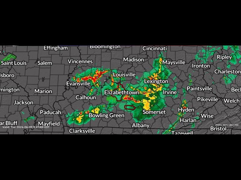
The Weather Now Kentucky radar image valid at 9:47 AM EDT Tuesday June 9th shows widespread moderate to heavy rainfall blanketing the state from the Louisville and Evansville area southward through Elizabethtown, Somerset, and toward Bowling Green. Severe weather chances remain on the table later today as the atmosphere continues to destabilize through the afternoon hours.
Flash Flood Warnings in Red Active From Louisville Through Elizabethtown Corridor
The active Flash Flood Warnings shown in red on the radar display cover portions of central Kentucky centered around the Louisville through Elizabethtown corridor, where the heaviest rainfall accumulations have already occurred through the morning hours. Red and orange radar returns in this zone indicate ongoing intense rainfall that is exceeding the ground’s ability to absorb water and local drainage capacity.
Residents across the warned areas should avoid all travel through flooded roadways and stay off low-lying roads and near streams until warnings expire.
Moderate Rain Filling Most of the State With Additional Heavy Pockets Developing
Beyond the Flash Flood Warning area, the broader radar image shows widespread moderate green returns covering most of Kentucky from the Paducah and Bowling Green corridor northeastward through Lexington, Maysville, and toward the Ohio border. Additional heavier pockets of yellow and orange are scattered across the state, indicating the potential for additional flood concerns in areas that receive repeated rounds of heavy rainfall through the morning and afternoon.
Never drive through water-covered roadways regardless of how familiar the route or how shallow the water appears.
Severe Weather Chances Still in the Afternoon Forecast for Kentucky
Beyond the ongoing flash flooding concerns, additional severe weather potential exists later Tuesday afternoon as the atmosphere continues to destabilize behind the morning rain complex. Residents across Kentucky should remain weather aware through the afternoon and evening hours with multiple ways to receive both flash flood and severe thunderstorm warnings active.
Monitor radar conditions continuously through Tuesday and avoid flooded roadways at all times. Stay with NapervilleLocal.com for the latest weather updates and local forecast coverage.

I’ve lived in Naperville long enough to see how quickly our community changes — from new developments downtown to sudden shifts in our Midwest weather. Reporting on Naperville news and daily forecasts gives me the chance to keep neighbors informed about what really matters. My goal is simple: deliver clear, timely updates so you always know what’s happening in our city and what to expect from the skies above.