
Active Storm Track in Texas, Arkansas, Louisiana, Mississippi, Alabama, Tennessee, and Kentucky With Severe Weather Risk January 8–12
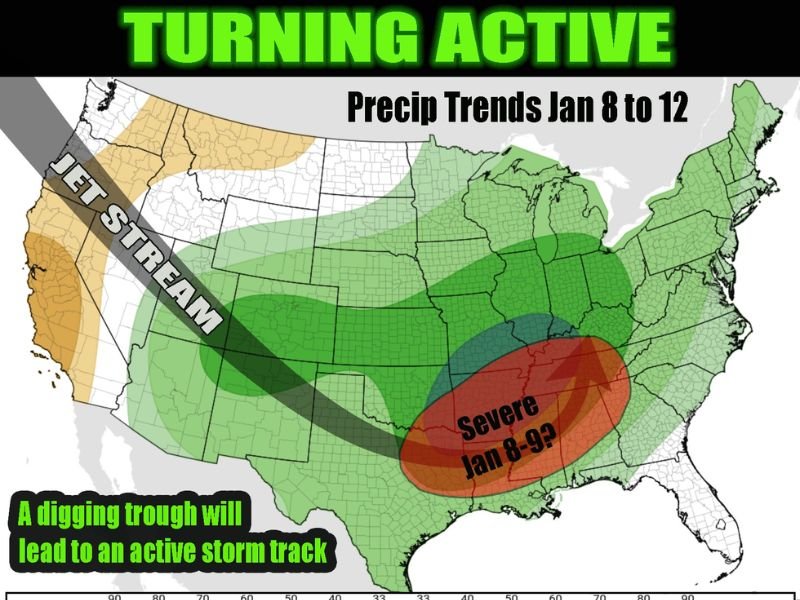
TENNESSEE – Forecast data for January 8 through January 12 indicates a shift toward a wetter and more active storm track across large portions of the southern and central United States, driven by a strengthening jet stream and increasing atmospheric moisture. Guidance suggests this pattern could support the year’s first organized severe weather system, particularly between January 8 and January 9.
The data shows warmer-than-average temperatures and rising moisture levels spreading northward ahead of the storm track, creating conditions favorable for strong thunderstorms across multiple states.
Jet Stream Pattern Signals Increasing Storm Activity
The map highlights a pronounced jet stream extending from the Southwest into the central and eastern United States, a classic setup for frequent storm development. This fast-moving upper-level wind pattern helps organize storm systems and transport moisture into areas that are normally quieter in early January.
As the jet stream becomes more active, precipitation coverage increases across much of the country. The strongest signal for enhanced storm development appears across the Lower Mississippi Valley and Tennessee Valley, where atmospheric ingredients align most efficiently.
Severe Weather Risk Centers on the South and Tennessee Valley
The highest concern for severe weather is focused across eastern Texas, Arkansas, Louisiana, Mississippi, Alabama, Tennessee, and western Kentucky, with the most critical window currently projected for January 8–9.
Within this region, storms could become organized and strong, especially where warm, moist air interacts with the advancing system. While exact hazards will become clearer closer to the event, patterns like this are commonly associated with damaging winds, heavy rainfall, and isolated severe thunderstorms.
Precipitation Trends Point to Widespread Rainfall
Beyond the severe weather zone, the broader forecast from January 8 to January 12 shows above-normal precipitation stretching from the Southern Plains through the Midwest and into parts of the Northeast. This suggests a busy stretch of weather, with repeated systems moving along the same corridor.
Areas farther north may see rain-dominated systems due to the warmer temperature profile, while colder air remains displaced well to the north and west during this period.
Why This Pattern Matters Heading Deeper Into January
An active storm track this early in the year often signals a broader pattern change, not just a single event. With warmer-than-average air and moisture present, the atmosphere becomes more efficient at producing impactful systems, increasing the likelihood of additional storms later in the month.
Residents across the South, Tennessee Valley, and lower Midwest should remain alert as forecasts are refined, especially as confidence grows in timing and severity. For continued coverage that explains how large-scale weather patterns translate into real regional impacts, follow ongoing updates from NapervilleLocal.com.

I’ve lived in Naperville long enough to see how quickly our community changes — from new developments downtown to sudden shifts in our Midwest weather. Reporting on Naperville news and daily forecasts gives me the chance to keep neighbors informed about what really matters. My goal is simple: deliver clear, timely updates so you always know what’s happening in our city and what to expect from the skies above.