
After 4 PM Friday: Strong Storms and Heavy Rain Spread Across Texas With Flooding Risk Into Saturday Morning
TEXAS — Another round of active weather is set to impact the region beginning Friday afternoon, bringing showers and thunderstorms that will continue into early Saturday morning. The system is expected to produce widespread rainfall, with some storms turning strong, especially north and northwest of the Dallas–Fort Worth area.
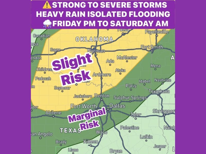
Storms Develop Late Friday Afternoon
Storm activity is expected to begin developing after 4:00 PM Friday, initially forming across parts of North Texas.
The strongest storms are likely to stay focused north and northwest of the Dallas–Fort Worth Metroplex, while areas closer to and south of the metro area may see weaker storms with only a marginal severe risk.
Stronger Storms Stay North of DFW Area
The severe weather setup shows a slight risk zone positioned north and northwest, where storms could be more organized and intense.
Meanwhile, the Dallas–Fort Worth area and surrounding regions fall into a marginal risk zone, meaning storms are expected to weaken somewhat as they move into these areas.
Heavy Rainfall and Flooding Risk Increase
This system is expected to bring more widespread and heavier rainfall compared to earlier activity.
- General rainfall totals: 1.5 to 2.0 inches
- Isolated higher totals: Up to 3 inches, especially north of I-20
With repeated rounds of rain and storms, there is a growing concern for isolated flooding, particularly in areas that receive the heaviest rainfall.
Storms Continue Through Night Into Saturday
Periods of showers and thunderstorms will continue through Friday evening and overnight hours, maintaining wet conditions across the region.
By Saturday morning, a more organized line of storms along a cold front is expected to move through, bringing additional heavy rain before gradually exiting the area.
Conditions Improve After Saturday Morning
Rain and storm activity is expected to clear out later Saturday morning as the system moves east, allowing for improving conditions across Texas.
Overall, this setup highlights a prolonged period of rain with pockets of stronger storms and localized flooding risk, especially in northern parts of the region. Stay with NapervilleLocal.com for the latest weather updates and local forecast coverage.

I’ve lived in Naperville long enough to see how quickly our community changes — from new developments downtown to sudden shifts in our Midwest weather. Reporting on Naperville news and daily forecasts gives me the chance to keep neighbors informed about what really matters. My goal is simple: deliver clear, timely updates so you always know what’s happening in our city and what to expect from the skies above.