
Alabama and Surrounding States Could Face Strong Storms Next Week as Thanksgiving Weather Models Shift
BIRMINGHAM, ALABAMA — Earlier model forecasts hinting at a Thanksgiving snow event have now flipped, showing a much different — and possibly stormier — outlook across the Deep South. Meteorologists are warning that a strong upper-level system could trigger severe thunderstorms early next week, especially across Alabama, Mississippi, Tennessee, and Georgia.
Forecast Models Drop Thanksgiving Snow, Add Severe Weather Risk
The so-called “Thanksgiving snow” that appeared on models earlier this week has vanished, replaced by signals of volatile weather patterns. Experts say this shift reflects a transition phase between near-record warmth and a sharp December cold snap expected to follow.
According to long-range model data, while there’s no single guaranteed threat zone yet, the overall setup is unstable — and that means Alabama could see strong storms as temperatures and pressure patterns collide midweek.
“We’re not seeing a clear signal for winter weather right now,” meteorologists explained. “But we do see the ingredients for some sneaky, fast-moving storms, especially across Alabama during the transition.”
Tuesday and Wednesday Could Bring Wind Shear and Thunderstorms
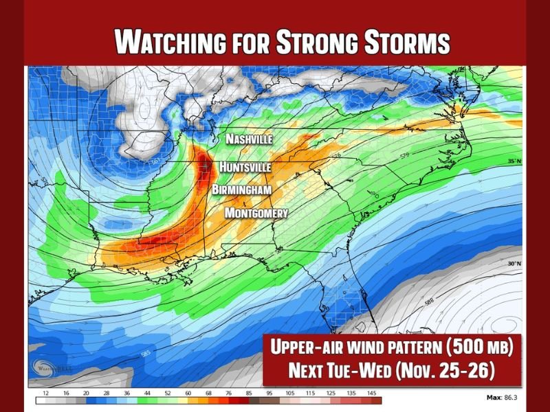
The upper-air wind pattern map shows a strong jet stream moving across the Gulf states, creating a corridor of wind shear and lift — both key ingredients for severe thunderstorms.
- Areas at highest risk include Birmingham, Montgomery, and Huntsville, extending into parts of Mississippi, Tennessee, and northern Georgia.
- The storm system will likely arrive Tuesday into Wednesday (Nov. 25–26), coinciding with busy Thanksgiving travel periods.
- At this stage, forecasters expect strong winds, heavy rain, and isolated severe storms, though tornado potential remains low for now.
“It’s too early to call this a tornado setup,” one meteorologist added. “But it’s the kind of pattern that can sneak in a few strong storms during the transition from warm to cold.”
Why This Pattern Matters
This developing system marks a shift from early-season warmth to the colder December air mass expected in the following week. Such temperature contrasts often fuel strong frontal systems, leading to periods of gusty winds, lightning, and heavy rain across the South.
Residents in Dixie Alley — which includes Arkansas, Louisiana, Mississippi, Alabama, Tennessee, and Georgia — should keep a close eye on local forecasts as conditions evolve.
Preparing for a Chaotic Thanksgiving Week
Forecasters urge residents to stay weather-aware, especially travelers planning to be on the road next week:
- Check updated forecasts daily as new model runs refine the timing.
- Keep emergency alerts enabled for storm warnings.
- Allow for travel flexibility in case of severe weather delays or heavy rainfall.
The situation remains fluid, but the message is clear: the Deep South may trade its Thanksgiving snow fantasy for a stormy and windy setup as November closes out.
Stay with NapervilleLocal.com for updated weather coverage and travel safety information throughout Thanksgiving week.

I’ve lived in Naperville long enough to see how quickly our community changes — from new developments downtown to sudden shifts in our Midwest weather. Reporting on Naperville news and daily forecasts gives me the chance to keep neighbors informed about what really matters. My goal is simple: deliver clear, timely updates so you always know what’s happening in our city and what to expect from the skies above.