
Alabama and Tennessee Face Rare Wide-Swath Winter Storm as Euro Model Signals Heavy Snow North and Major Ice South
ALABAMA — New European model data is raising serious concern about a large, sweeping winter storm threat extending unusually far south, with a dangerous combination of heavy snow and significant ice accumulation possible across Alabama and Tennessee from Friday night through Sunday morning. Forecasters emphasize that this is not a narrow or localized setup, but a broad, high-impact winter event capable of affecting multiple states at once.
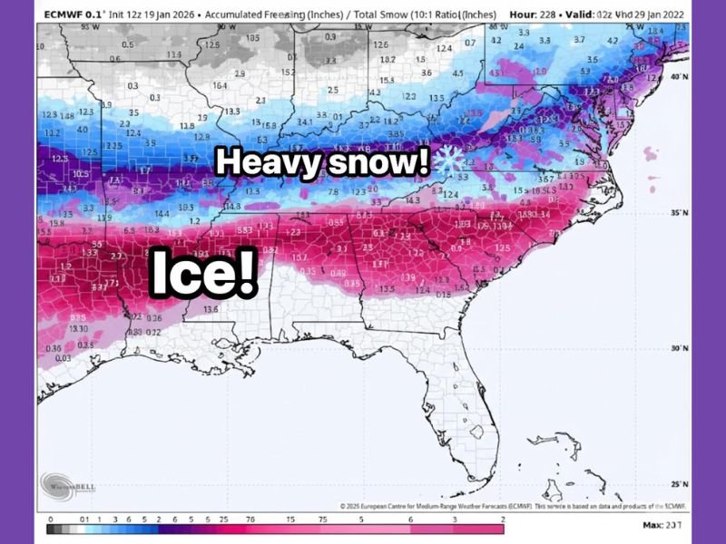
Euro Model Shows Unusually Large Ice and Snow Footprint
The latest ECMWF (European) model blend combines snow and freezing rain projections through next week, revealing what meteorologists describe as an exceptionally wide storm footprint. Rather than focusing on county-level precision, forecasters are urging attention to the overall scale of the system, which stretches roughly from Interstate 20 northward toward Interstate 70.
This type of expansive winter storm signal this far south is rare, especially one capable of producing both heavy snow on the northern edge and widespread ice to the south.
Dangerous Ice Zone Emerging Across the Deep South
The southern half of the storm shows a strong signal for freezing rain, with ice accumulation becoming the dominant concern across Alabama, particularly in areas closer to I-20. Even modest ice amounts can quickly escalate impacts:
- Less than 0.10 inches can create hazardous travel
- Around 0.25 inches increases the risk of power outages
- Higher amounts raise the threat of tree damage, downed lines, and extended outages
Forecasters warn that this setup favors long-duration freezing rain, which significantly increases the potential for infrastructure damage.
Heavy Snow Likely on Northern Edge of the System
North of the primary ice zone, colder air supports heavy snow accumulation, especially across Tennessee and points farther north. The transition zone between snow and ice remains volatile, meaning small shifts in temperature or storm track could dramatically change who sees snow versus ice.
This sharp gradient is one reason confidence in high-impact conditions is increasing, even as exact placement remains uncertain.
Timing Window for Alabama and Tennessee
Based on the current ECMWF guidance:
- Primary impacts begin Friday night
- Peak conditions occur Saturday
- Lingering impacts possible into Sunday morning
While details will continue to evolve, the timing window is becoming clearer, giving residents time to prepare.
Why This Storm Demands Attention Now
Meteorologists stress that this is not a hype-driven forecast, but a pattern-driven concern supported by consistent model signals. The combination of:
- Broad geographic coverage
- Cold air locked in place
- Warm, moisture-rich air overrunning the surface
creates an environment favorable for both ice and heavy snow across the region.
Bottom Line
A rare, wide-swath winter storm threat is taking shape across Alabama and Tennessee, with dangerous ice accumulation likely in the south and heavy snow possible to the north. While exact totals will change, the overall risk profile is increasing, not decreasing.
Residents should begin reviewing winter safety plans, preparing for potential power outages, and staying alert for forecast updates as the event approaches.
For continued winter storm coverage, forecast updates, and preparedness guidance, stay connected with NapervilleLocal.com.

I’ve lived in Naperville long enough to see how quickly our community changes — from new developments downtown to sudden shifts in our Midwest weather. Reporting on Naperville news and daily forecasts gives me the chance to keep neighbors informed about what really matters. My goal is simple: deliver clear, timely updates so you always know what’s happening in our city and what to expect from the skies above.