
Alabama Big Weather Shift Ahead: Cold Temperatures Sweep the Midwest and Plains While the Southeast Stays Warm
UNITED STATES — A major temperature divide is developing across the nation as November transitions into December, with cold air surging into the Midwest and Plains while the Southeast stays much warmer than usual.
According to updated model guidance, the highly anticipated Thanksgiving Arctic blast will arrive, but not as intense as once feared. Meteorologists describe it as “more refrigerator door than deep freezer,” especially for areas like Alabama and Tennessee.
Midwest and Plains Brace for Cold Surge
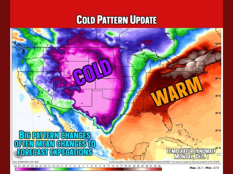
The European weather model shows a strong push of Arctic air dominating states across the Central Plains, the Rockies, and the Upper Midwest.
- Temperatures will drop well below seasonal averages for states such as Nebraska, Kansas, Colorado, and Iowa.
- Overnight lows could plunge into the teens and 20s, with some regions seeing daytime highs struggling to reach 40°F.
“This won’t be a record-breaking freeze, but it will definitely feel like winter for the heart of the country,” forecasters explained.
Southeast States Stay Warm
Meanwhile, the Southeast, including Florida, Georgia, and the Carolinas, is expected to stay unseasonably mild. Highs could reach 70°F or higher through early December as warm, moist air from the Gulf holds its ground.
This temperature contrast is creating a “weather seesaw” across the U.S., with one half of the country bundled in coats while the other enjoys near-springlike warmth.
December Outlook: Balancing Act Ahead
Meteorologists say the cold pattern isn’t gone — just moderated. The first week of December will likely bring fluctuating temperatures across much of the Midwest and Great Plains, followed by another cooldown.
- Colder-than-average conditions will persist for the central and northern states.
- The East Coast and Deep South may stay mostly dry and mild, with only brief dips in temperature.
Forecasters add that this back-and-forth trend is typical for early winter and signals an active jet stream pattern heading into mid-December.
Stay with NapervilleLocal.com for continuous updates as models refine the next major cold blast across the Midwest and beyond.

I’ve lived in Naperville long enough to see how quickly our community changes — from new developments downtown to sudden shifts in our Midwest weather. Reporting on Naperville news and daily forecasts gives me the chance to keep neighbors informed about what really matters. My goal is simple: deliver clear, timely updates so you always know what’s happening in our city and what to expect from the skies above.