
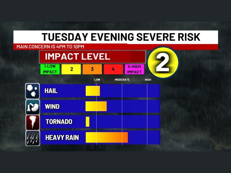
Alabama Birmingham and Tuscaloosa Under 4 PM to 10 PM Storm Window With Heavy Rain Lightning and Gusty Winds Driving Tuesday Evening Risk
BIRMINGHAM, ALABAMA — A window for potentially strong storms is expected to develop across parts of Alabama this afternoon into the evening, with the main concern centered between 4 PM and 10 PM.
While not all areas will see severe weather, conditions are favorable for scattered strong storms capable of producing heavy rain, intense lightning, and gusty winds.
Key Storm Window Focused on Late Afternoon and Evening
Forecast data highlights a defined timing window where storm activity is most likely to intensify.
The primary period of concern includes:
- 4 PM to 10 PM: Highest chance for strong storms
- Storms developing and moving through in scattered fashion
- Activity gradually decreasing later into the night
This timing suggests impacts could overlap with evening travel and outdoor plans.
Heavy Rain and Gusty Winds Lead Main Threats
The overall impact level is considered moderate, with the most consistent hazards expected to be:
- Heavy rainfall, which could lead to brief localized flooding
- Frequent lightning, especially in stronger storm cores
- Gusty winds, capable of causing minor impacts
There is also a lower-end potential for:
- Hail in isolated storms
- A very limited tornado risk, though confidence remains low
Why Severe Potential Remains Uncertain
One of the key uncertainties in this setup is how much instability can build during the afternoon.
Several factors could influence storm strength:
- Cloud cover limiting daytime heating
- Early showers reducing instability
- Or partial clearing allowing stronger storm development
If sunshine breaks through during the afternoon, storm intensity could increase. If not, storms may remain below severe levels.
Not Everyone Will See Severe Weather
This is a conditional setup, meaning:
- Some areas may experience only rain and thunder
- Others could see stronger storms with heavier impacts
The scattered nature of the system means conditions may vary significantly even within short distances.
Residents Should Stay Weather Aware
Even with uncertainty, residents across areas including:
- Birmingham
- Tuscaloosa
- Surrounding central Alabama communities
should remain alert during the evening hours.
Recommended precautions include:
- Monitoring weather updates throughout the afternoon
- Preparing for sudden downpours and lightning
- Staying aware of rapidly changing conditions
A Watchful Evening Ahead Across Alabama
While this is not expected to be a widespread severe outbreak, the setup carries enough uncertainty to warrant close attention.
A few stronger storms could develop quickly and bring localized impacts during the evening window. Conditions will continue to be monitored as storms develop across Alabama later today. Stay with NapervilleLocal.com for continued weather updates and real-time coverage.

I’ve lived in Naperville long enough to see how quickly our community changes — from new developments downtown to sudden shifts in our Midwest weather. Reporting on Naperville news and daily forecasts gives me the chance to keep neighbors informed about what really matters. My goal is simple: deliver clear, timely updates so you always know what’s happening in our city and what to expect from the skies above.