
Alabama Braces for 80-Degree Warmth, Weekend Storm Risk, Then a Sharp Freeze as February Swings Wildly
ALABAMA — A dramatic late-February weather swing is unfolding across the state, starting with near-record warmth today before transitioning into a weekend system capable of strong storms, followed by a sharp blast of colder air early next week.
Near-Record Warmth Takes Over Today
Temperatures across Alabama are projected to climb into the 75–82 degree range, making this one of the warmest days of the year so far for many communities.
Only a few isolated showers are expected today, but the main headline is the unusual warmth for mid-February. Many locations across central and southern Alabama will experience spring-like conditions before a front begins moving in overnight.
“Windshield Wiper” Front Brings Rounds of Rain
After midnight, a surface front will slide into Alabama and drift into the central portion of the state by midday Friday, where it stalls.
From there, the system behaves in what forecasters describe as a “windshield wiper” pattern:
- The boundary lifts north Friday night as a warm front.
- It swings south again Saturday as a cold front.
This back-and-forth motion will trigger multiple rounds of showers and a few thunderstorms.
Rain will initially impact North Alabama late tonight into early Friday, then spread into southern counties during the day. Another round of rain redevelops over northern sections Friday night into early Saturday before shifting south again by Saturday afternoon. Most communities are expected to receive under one inch of total rainfall through Saturday night.
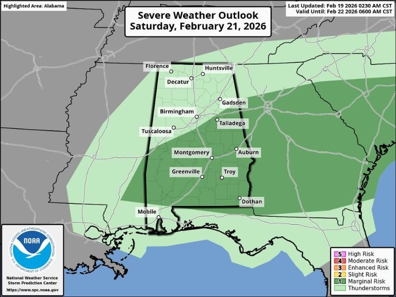
Marginal Severe Risk for South and Southeast Alabama
The Storm Prediction Center has outlined a low-end “marginal risk” for severe thunderstorms Saturday afternoon across parts of South and Southeast Alabama.
The highest concern appears to be mainly south and east of Montgomery, where slightly unstable air ahead of the front could support a few stronger storms. While widespread severe weather is not expected, isolated strong storms cannot be ruled out.
Colder Air Surges in Sunday
Once the front clears the region, conditions change quickly. Sunday will turn mostly sunny, breezy, and much colder, with highs dropping into the 48–58 degree range statewide.
By early Monday, a freeze is likely across the northern half of Alabama. Temperatures could dip even further by Tuesday morning, with readings falling into the 20s deep into South Alabama.
Warmer Pattern Returns by Midweek
The cold snap will not last long. A warming trend begins Tuesday afternoon, and by late next week, highs across South Alabama are expected to return to the low 70s.
Long-range guidance suggests rain and possibly a few thunderstorms could return by Thursday ahead of another approaching cold front.
For continued updates on major weather swings impacting communities across the country, stay connected with NapervilleLocal.com for the latest forecasts and developments.

I’ve lived in Naperville long enough to see how quickly our community changes — from new developments downtown to sudden shifts in our Midwest weather. Reporting on Naperville news and daily forecasts gives me the chance to keep neighbors informed about what really matters. My goal is simple: deliver clear, timely updates so you always know what’s happening in our city and what to expect from the skies above.