
Alabama Braces for Bitter Cold, Gusty Winds, and Spotty Snow as Winter Alerts Expand Across Eastern Counties
ALABAMA — A surge of Arctic air is settling across the state tonight, setting up a dangerously cold and blustery 24-hour stretch with scattered snow showers, icy travel risks, and strong north winds impacting much of Alabama through tomorrow. Forecasters say the combination of cold temperatures, wind, and light snow could make conditions feel far more severe than snowfall totals alone might suggest.
Arctic Air Pushes Temperatures Into the 20s Statewide
Very cold air is spilling into Alabama tonight and will dominate the forecast through tomorrow. Temperatures across the northern half of the state are expected to remain in the 20s, while even typically milder southern cities such as Dothan and Mobile may struggle to climb above the freezing mark.
The persistent cold will be reinforced by strong winds, driving wind chill values much lower than actual air temperatures and increasing the risk of exposure for anyone spending time outdoors.
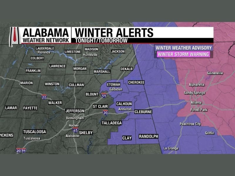
Snow Showers Likely Late Tonight and Friday Morning
Scattered snow showers are expected to develop in the colder air late tonight and continue into Friday morning, with the highest coverage focused over northeast and east Alabama.
A Winter Weather Advisory is in effect for six counties in east Alabama, where some locations could see up to one inch of snow, particularly under heavier snow showers. While snowfall amounts are generally expected to remain light, even small accumulations could create slick and icy road conditions, especially on bridges and elevated surfaces.
Icy Spots and Hazardous Travel Possible
Where snow showers develop, icy patches may form quickly due to cold ground temperatures. Travel conditions could deteriorate rapidly in localized areas, especially during the morning commute.
Drivers are urged to use caution, reduce speeds, and remain alert for sudden changes in road conditions, particularly in advisory areas.
Powerful North Winds Add to the Danger
An icy north wind will strengthen through the day tomorrow, with gusts reaching 30 to 40 mph across much of Alabama. A Wind Advisory covers large portions of the state, and the gusty conditions will significantly worsen wind chills and make outdoor conditions feel harsh.
The strong winds may also contribute to blowing snow in areas where snow showers occur, briefly reducing visibility and adding to travel concerns.
Cold, Wind, and Snow Create a High-Impact Combination
While widespread heavy snow is not expected, meteorologists emphasize that the combination of cold temperatures, gusty winds, and spotty snow showers poses a meaningful risk. Wind chills will dip sharply, icy roads may develop quickly, and even brief snow bursts could cause sudden hazards.
Residents are encouraged to dress in layers, limit time outdoors when possible, and prepare for rapidly changing conditions.
What to Expect Through Tomorrow
Cold conditions will persist through Friday, with temperatures remaining well below normal. Snow showers should gradually diminish later in the day, but cold air and gusty winds will continue to make conditions uncomfortable and potentially dangerous.
NapervilleLocal.com will continue tracking winter weather developments across Alabama and provide updates as conditions evolve.

I’ve lived in Naperville long enough to see how quickly our community changes — from new developments downtown to sudden shifts in our Midwest weather. Reporting on Naperville news and daily forecasts gives me the chance to keep neighbors informed about what really matters. My goal is simple: deliver clear, timely updates so you always know what’s happening in our city and what to expect from the skies above.