
Alabama Braces for Near 70° Warm-Up and Heavy Rain by Thursday as Cold Front Sparks Windy Storm Threat
ALABAMA — After a chilly start to the week, a dramatic warm-up is expected to push temperatures close to 70 degrees by Thursday, setting the stage for a round of heavy rain and gusty storms across much of the state.
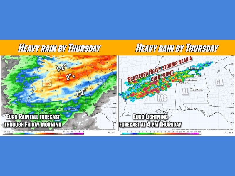
Forecast models show a strong cold front sweeping into Alabama late Thursday, bringing widespread rainfall and scattered heavier storms. While recent systems have underperformed in rainfall totals, this setup appears more organized — though some uncertainty remains.
Rainfall Totals Could Reach 1–2 Inches
The European model indicates a broad swath of 1 to 2 inches of rain across much of Alabama, particularly north of Ozark and Evergreen. Areas including Birmingham, Tuscaloosa, Huntsville, and Gadsden appear positioned for the heaviest totals.
However, forecasters remain cautiously optimistic. While 1–2 inches is possible in spots, a more conservative expectation for many communities is 0.5 to 1 inch by Thursday night into early Friday morning. Rainfall coverage appears widespread, with the heaviest bands likely aligning along and just ahead of the advancing cold front.
Storms Likely, But Severe Threat Low
Storm activity is expected to develop along the frontal boundary as it pushes east. The forecast suggests scattered heavy storms could form, especially across central and northern Alabama Thursday afternoon and evening.
At this time, widespread severe weather does not appear likely. However, gusty winds will accompany the front. Wind conditions could resemble the breezy pattern experienced earlier in the week, with strong gusts possible as the system moves through.
Residents should prepare for:
- Periods of moderate to heavy rain
- Brief downpours in stronger cells
- Gusty winds during frontal passage
- Rapid temperature changes after the front clears
Quick Shift From Cold to Springlike
The rapid temperature swing from cold Monday morning conditions to near-70° warmth by Thursday highlights the dynamic nature of late-winter weather in the Southeast. The warming trend will help fuel instability ahead of the cold front, though current data suggests limited severe potential. Behind the front, cooler air is expected to return by Friday, ending the brief warm stretch.
Travel and Outdoor Impacts
Thursday could feature soggy commutes, particularly during the afternoon and evening hours. Drivers across central and northern Alabama should allow extra time and watch for ponding on roads during heavier rainfall bursts. Outdoor plans may need adjustments as winds increase and storms move through.
While the system may not produce widespread severe weather, it will likely deliver a noticeable soaking across much of the state. For continued national weather updates and major storm coverage, stay connected with NapervilleLocal.com.

I’ve lived in Naperville long enough to see how quickly our community changes — from new developments downtown to sudden shifts in our Midwest weather. Reporting on Naperville news and daily forecasts gives me the chance to keep neighbors informed about what really matters. My goal is simple: deliver clear, timely updates so you always know what’s happening in our city and what to expect from the skies above.