
Alabama Braces for Unseasonably Warm March Stretch With Temperatures Near 80 and Weekend Storm Chances Across Northern Counties
Alabama — A stretch of unseasonably warm March weather is settling across Alabama, with many communities expected to reach temperatures at or above 80 degrees through Saturday as a warm air mass spreads across the Southeast. While most of the state will remain dry during the day, meteorologists say isolated showers could briefly develop in the southeastern corner of Alabama later this afternoon.
The overall pattern resembles summer-like conditions, with warm afternoons, mild nights, and only isolated pockets of rainfall expected through the end of the week. Forecasters say the warm trend will continue for several days before a weekend weather system brings scattered showers and a low-end thunderstorm risk to parts of the state.
Temperatures Climb Into the 80s Across Much of Alabama
Temperature forecasts show widespread warmth across Alabama, with several cities expected to reach or exceed the 80-degree mark during the coming days.
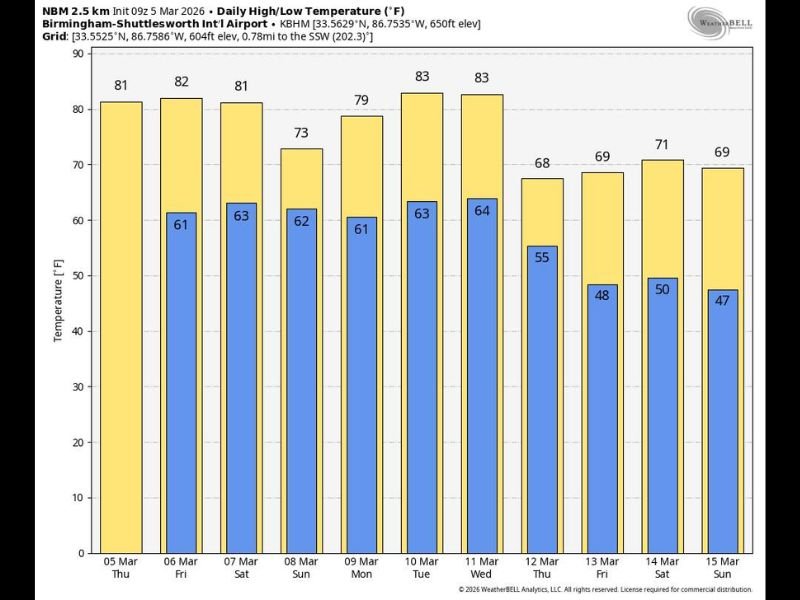
Cities such as Birmingham, Montgomery, Tuscaloosa, Auburn, and Dothan are expected to experience warm afternoons, with highs generally around the upper 70s to low 80s. Northern communities including Huntsville, Florence, and Decatur are also forecast to see mild conditions approaching 80 degrees, making the weather feel much more like late spring than early March.
This warming trend is being driven by southerly winds pulling warmer air northward across the Gulf Coast region, creating a noticeable rise in temperatures throughout the state. Meteorologists say these warmer conditions are expected to remain in place through Saturday, maintaining the mild pattern across most Alabama communities.
Weekend Storm System Could Bring Showers to Northern Alabama
While the first part of the forecast period will remain mostly dry, a weather system moving toward the state this weekend could introduce scattered showers and thunderstorms, particularly across the northwestern portion of Alabama.
Saturday morning is expected to begin dry, but during the afternoon showers and a few thunderstorms may develop in the northwest region before gradually moving southward later in the evening.
Forecast guidance suggests that this system may weaken as it travels across the state, but meteorologists are still monitoring the potential for isolated strong storms across northern Alabama. The Storm Prediction Center has introduced a marginal severe weather risk (Level 1 out of 5) for roughly the northern three-quarters of Alabama, indicating that a few stronger thunderstorms cannot be ruled out.
However, forecasters emphasize that severe weather conditions currently appear limited, as atmospheric instability remains relatively weak.
What the Forecast Looks Like Heading Into Next Week
After the weekend system moves through, a stalled front near the northwest part of Alabama may keep scattered showers and thunderstorms in the forecast for Sunday, though rainfall will likely remain spotty rather than widespread.
Temperatures on Sunday are expected to cool slightly but remain mild, with highs generally staying in the 70-degree range across most of the state. Looking ahead to next week, meteorologists expect mostly warm and dry conditions on Monday and Tuesday, before another cold front approaches later in the week.
That front could bring another round of showers and thunderstorms to Alabama late Wednesday night and Thursday, though it remains too early to determine whether severe storms will develop. Behind that system, cooler air may return to the region, bringing afternoon temperatures back into the 65 to 75 degree range by the end of the week.
The current forecast highlights how early March weather across the Southeast can rapidly shift between springlike warmth and passing storm systems, creating a dynamic weather pattern across the region. For continuing coverage of major weather trends and regional forecasts across the United States, readers can stay updated with the latest reports on NapervilleLocal.com.

I’ve lived in Naperville long enough to see how quickly our community changes — from new developments downtown to sudden shifts in our Midwest weather. Reporting on Naperville news and daily forecasts gives me the chance to keep neighbors informed about what really matters. My goal is simple: deliver clear, timely updates so you always know what’s happening in our city and what to expect from the skies above.