
Alabama Rain Moves Out This Morning as Temperatures Climb Into the 60s Before 80-Degree Warmth Arrives Later This Week
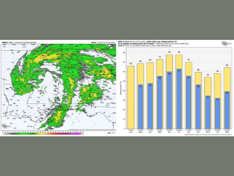
Birmingham, Alabama — A widespread area of steady rain is sweeping across Alabama early this morning, but conditions are expected to gradually improve as the system exits the state later today. Forecasters report no thunder, no severe storm risk, and no flooding concerns, offering reassurance despite the wet start. Afternoon temperatures are projected to climb into the 60s, which is close to seasonal averages for mid-February.
Radar imagery shows a broad shield of rain stretching across much of the state, impacting areas from Central Alabama into South Alabama. While rainfall coverage is widespread this morning, intensity remains moderate and non-severe. As the upper-level trough responsible for the system continues moving east, rain will taper off from west to east by late morning.
Showers Diminish Today, Isolated Rain Possible Later
Although the main batch of rain will clear the state later this morning, a few isolated showers may redevelop this afternoon as the upper trough swings through. Skies will likely remain mostly cloudy for much of the day, but improving conditions are expected heading into tonight.
Temperatures are forecast to reach the low to mid-60s statewide, providing a mild finish to what began as a damp morning. Light winds and the absence of severe weather threats make today more of a nuisance rain event rather than a hazardous situation. Residents should still use caution during the morning commute due to wet roadways, but widespread travel disruptions are not anticipated.
Warmest Week of the Year Ahead
Looking ahead, Alabama is on track to experience its warmest week of the year so far. By Thursday and Friday, many communities across Central and South Alabama are expected to reach the low 80s for the first time in 2026. This surge in warmth marks a sharp transition from the cooler conditions seen earlier in the month.
Forecast projections show highs steadily rising through midweek, with temperatures climbing from the upper 60s and low 70s into the upper 70s before peaking in the 80-degree range late in the week. Conditions during this stretch are expected to be generally dry, although a few isolated showers could develop toward the end of the week.
Weekend Showers and Possible Freeze Next Week
Rain chances increase again over the February 21–22 weekend as another system approaches ahead of a cold front. While details are still developing, scattered showers appear likely.
Behind that front, noticeably cooler air will move into the state by Sunday and early next week (February 22–24). A freeze may be possible across the northern two-thirds of Alabama around Tuesday morning, February 24, before temperatures rebound later in the week.
This pattern highlights Alabama’s typical late-winter swings — from mild rain and 60s today, to early spring warmth in the 80s, followed by another cool-down. For continued coverage of major weather patterns and regional updates affecting communities nationwide, visit NapervilleLocal.com for in-depth analysis and daily reports.

I’ve lived in Naperville long enough to see how quickly our community changes — from new developments downtown to sudden shifts in our Midwest weather. Reporting on Naperville news and daily forecasts gives me the chance to keep neighbors informed about what really matters. My goal is simple: deliver clear, timely updates so you always know what’s happening in our city and what to expect from the skies above.