
Alabama Stays Dry With Highs Near 80 Through Friday Before a Cooler Weekend Arrives and Warm 80s Return Next Week
BIRMINGHAM, ALABAMA — Alabama’s dry weather pattern is set to continue through the end of the workweek, keeping most communities warm, rain-free, and steadily trending above normal before a late Friday front brings a brief cooldown for the weekend. Forecast temperatures show much of the state climbing through the upper 70s and 80s over the next two days, with very limited rain chances for most areas.
The pattern does not appear to bring meaningful widespread rainfall anytime soon, which means the state’s unusually dry stretch will remain the bigger story even as temperatures swing up and down over the next several days.
Warm and Dry Conditions Continue Across Alabama
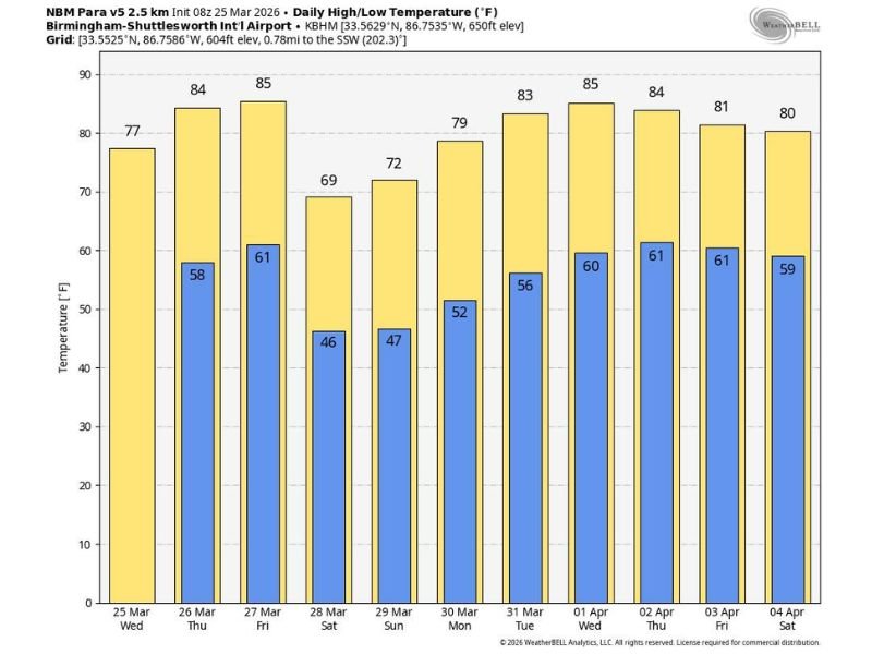
Temperatures across Alabama are expected to stay comfortably warm today, with many communities reaching the 74 to 80 degree range. That warmth will build even more on Thursday and Friday, when highs are expected to move into the 80s statewide. The temperature chart tied to Birmingham supports that trend, showing highs rising from the upper 70s Wednesday to the mid-80s by Thursday and Friday.
This kind of setup keeps outdoor conditions favorable for much of the state, especially with no widespread rain expected during the day. For many communities, the bigger weather theme remains the persistence of dry conditions rather than any immediate storm threat.
Friday Brings Warmth Again Before a Front Moves In
Friday is expected to remain another warm day, with highs in the 80s across Alabama before a cold front begins moving in later in the day and into Friday night. Most areas are still expected to stay dry for much of Friday, but there is at least some mention of isolated showers by Friday evening, especially across the Tennessee Valley ahead of the front.
That means northern sections of the state may see the first signs of change before the rest of Alabama. Even so, the forecast does not suggest a major rain event. Instead, the front looks more like a temperature changer than a widespread soaking rainmaker.
Cooler Air Arrives for the Weekend
Behind the Friday night front, cooler air is expected to settle into the state for Saturday. The northern third of Alabama is forecast to see highs in the 60s, while much of the rest of the state stays in the low to mid-70s. That will make Saturday feel noticeably different from the warmer conditions expected Thursday and Friday.
By Sunday, temperatures are expected to recover somewhat, with highs returning to the 70s. The weekend forecast also points to plenty of sunshine both days, which should keep conditions pleasant despite the cooler air mass moving through.
Next Week Turns Warm Again but Still Dry
The longer-range trend shows little change in Alabama’s dry pattern. Forecast guidance indicates there is still no sign of meaningful rainfall through next week, even as afternoon highs begin climbing back into the 80s by Tuesday and continue there through the rest of the week.
The Birmingham temperature chart reflects that rebound clearly, with highs rising back into the low to mid-80s from Tuesday through Saturday of next week. Overnight lows also trend milder again, showing that this cooldown will be brief rather than the start of a longer cool stretch.
Dry Pattern Remains the Bigger Concern
While the short-term forecast includes a small shower chance Friday evening in parts of the Tennessee Valley, the overall message remains the same for Alabama: warm weather, limited rain, and an ongoing dry pattern. That is important because repeated dry days can continue to build rainfall deficits if this pattern lasts much longer.
For now, Alabama is set to move from warm to briefly cooler and then right back to warm again, all with very little rain to interrupt the trend. Stay with NapervilleLocal.com for more weather updates, temperature swings, and developing forecast changes across Alabama and the rest of the country.

I’ve lived in Naperville long enough to see how quickly our community changes — from new developments downtown to sudden shifts in our Midwest weather. Reporting on Naperville news and daily forecasts gives me the chance to keep neighbors informed about what really matters. My goal is simple: deliver clear, timely updates so you always know what’s happening in our city and what to expect from the skies above.