
Alabama Temperatures Surge Toward Record Highs Near 80 as Patchy Fog Clears and Weekend Storms Begin Moving Toward Birmingham Region
Alabama — Warm springlike weather is returning across the state today as temperatures climb back into the 80-degree range in many communities, approaching levels that could challenge early-March records. Meteorologists say patchy fog and low morning clouds will gradually clear, allowing a mix of clouds and sunshine to dominate through the afternoon.
Light southerly winds between 5 and 10 mph are helping transport warmer air into the region, creating a noticeably mild feel across much of Alabama. While the day is expected to remain mostly dry, forecasters note that a stray shower cannot be completely ruled out.
Overall, the pattern reflects a classic early-spring setup in the Southeast, where warm temperatures and increasing moisture begin to support occasional scattered rain showers.
Foggy Morning Clears as Temperatures Approach Record Levels
Early morning conditions across parts of Alabama may include patchy fog and lingering low cloud cover, especially in valleys and areas that experienced overnight cooling.
As the morning progresses, these clouds are expected to lift, allowing partly to mostly cloudy skies with periods of sunshine during the afternoon hours.
Temperature forecasts indicate that several communities across the state could approach or exceed the 80-degree mark, including cities such as:
- Birmingham
- Tuscaloosa
- Hoover
- Clanton
- Anniston
- Alexander City
These temperatures are significantly warmer than typical early-March averages and reflect a temporary surge of warm air moving north from the Gulf region.
Despite the warmth, meteorologists say humidity levels remain moderate, meaning the day should feel comfortable rather than overly muggy.
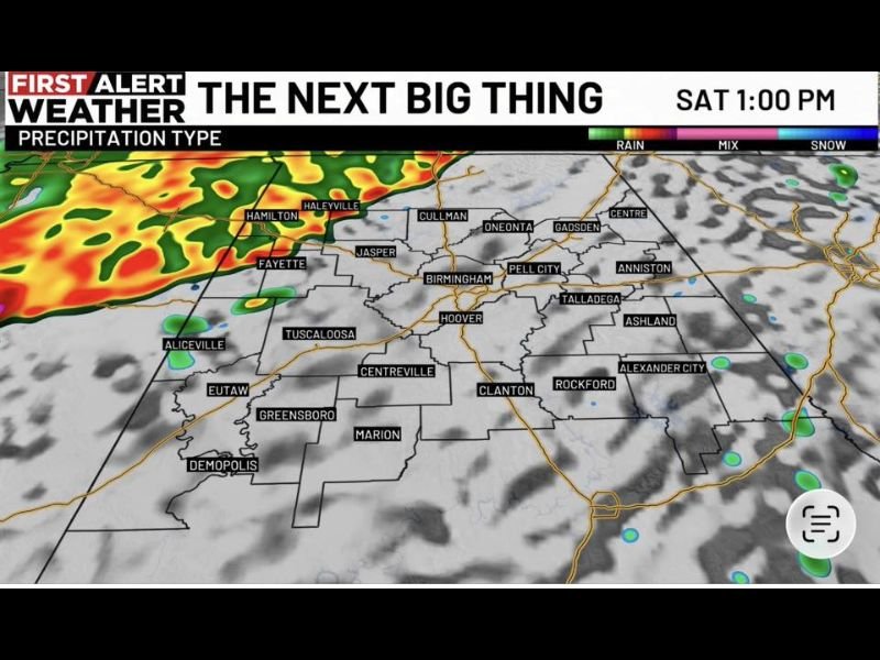
Weekend Rain and Storm Chances Begin Moving Into Alabama
Weather conditions will begin shifting as the weekend approaches, when a more organized area of showers and thunderstorms moves toward Alabama from the west.
Forecast models show the system gradually approaching northwestern parts of the state Saturday afternoon, with rain bands initially developing near communities such as:
- Hamilton
- Haleyville
- Fayette
- Aliceville
As the system progresses eastward, scattered showers and thunderstorms could spread toward the Birmingham area later in the day.
Meteorologists say severe weather is not currently expected, but some thunderstorms could produce brief gusty winds and lightning.
The activity may weaken as it travels farther into the state, though spotty rain and storms could still occur in central Alabama Saturday evening.
Scattered Storms Continue Into Sunday and Early Next Week
The weather system is expected to stall near the region, keeping scattered showers and thunderstorms possible through Sunday.
However, forecasters emphasize that rain will likely be scattered rather than continuous, meaning many areas may experience dry periods between passing showers.
Temperatures are expected to remain warm despite the unsettled weather, continuing the springlike pattern across the state.
Looking into next week, Monday and Tuesday could bring additional scattered showers, but much of the time should remain warm and partly cloudy.
Meteorologists are also monitoring the potential for a stronger weather system developing between Wednesday and Thursday, which could bring a more impactful round of rain and storms.
For now, Alabama residents can expect a mix of warm temperatures, occasional showers, and changing spring weather patterns as the region transitions deeper into the early spring season.
For continuing updates on major weather developments and regional forecast changes across the United States, readers can follow the latest weather reports and updates on NapervilleLocal.com.

I’ve lived in Naperville long enough to see how quickly our community changes — from new developments downtown to sudden shifts in our Midwest weather. Reporting on Naperville news and daily forecasts gives me the chance to keep neighbors informed about what really matters. My goal is simple: deliver clear, timely updates so you always know what’s happening in our city and what to expect from the skies above.