
Alabama, Tennessee, Georgia and Northern Florida Prepare for Dangerous Arctic Blast as Temperatures Plunge Into the Teens and Single Digits by Monday Morning
ALABAMA — A powerful Arctic blast sweeping into the eastern United States will drive temperatures sharply lower across Alabama, Tennessee, Georgia, and northern Florida, creating the region’s coldest air of the winter season. By early Monday morning, temperatures are expected to fall into the teens and single digits, with parts of the Midwest dropping below zero.
Rapid Temperature Drop Expected Sunday Into Monday
According to the latest forecast guidance, temperatures will begin plunging very early Sunday morning, dropping from the 40s and 50s into the 20s and 30s by afternoon across Alabama and neighboring states. This quick drop marks the arrival of the Arctic front, which will continue strengthening overnight.
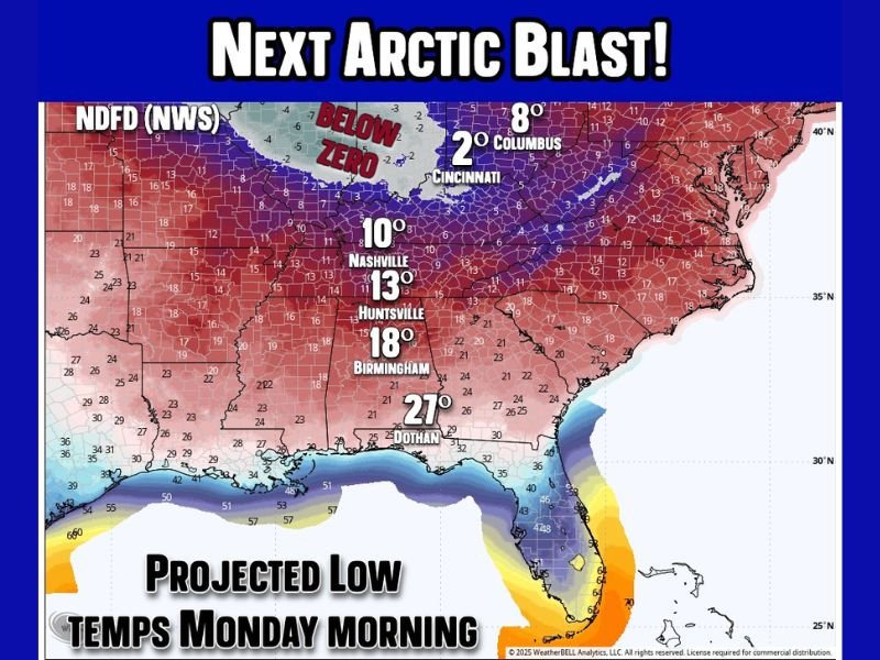
The NWS low-temperature map shows:
- 10°F in Nashville (Tennessee)
- 13°F in Huntsville (North Alabama)
- 18°F in Birmingham (Central Alabama)
- 27°F in Dothan (Southeast Alabama)
- 2°F in Columbus (Ohio)
- 8°F in Cincinnati (Ohio)
These values reflect a widespread and unusually intense surge of cold air reaching deep into the Southeast.
Meteorologists note that while not record-setting for the region as a whole, isolated record lows may occur in Alabama, Tennessee, and sections of the Appalachian Mountains.
How This Cold Compares to Recent Weather Across the Region
Forecasters say the level of cold arriving Sunday and Monday is significantly sharper than previous cold snaps this month. One comparison made was that this is the winter equivalent of isolated 105–110°F heat index days in summer — most days are hot, but a few reach a level that stands out. This Arctic outbreak will be that standout event for early winter.
Residents across Alabama, Tennessee, and Georgia should expect a distinctly harsher feel than earlier cold events, with brisk winds making morning conditions feel even colder.
Lowest Temperatures Expected Monday Morning
The coldest readings are forecast to occur before sunrise Monday, when temperatures could fall as low as:
- 10–15°F in North Alabama
- 15–20°F in Jefferson, Shelby, and Tuscaloosa Counties
- Low teens across central Tennessee
- Upper teens across northern Georgia
- Upper 20s in northern Florida, including areas near Tallahassee
The Midwest will experience even stronger cold, with widespread below-zero temperatures extending into the Ohio Valley, helping push the Arctic air mass southward.
Officials warn that freezing temperatures this deep into the Southeast can stress infrastructure, affect agriculture, and pose risks to people and pets unprepared for such abrupt cold.
How Long Will the Arctic Blast Last?
The good news: the intense cold will be short-lived.
- Sunday: Bitter and sharply colder air arrives.
- Monday: Still very cold in the morning, but sunny and less harsh by afternoon.
- Midweek: Temperatures rebound quickly into the 50s, with some areas even reaching the 60s by late week.
This brief but powerful blast will not linger long enough to establish a prolonged cold pattern — but the sudden drop will be significant while it lasts.
As winter conditions continue developing across multiple states, stay informed with NapervilleLocal.com for updates, safety recommendations, and extended weather outlooks across Alabama, Tennessee, Georgia and northern Florida.

I’ve lived in Naperville long enough to see how quickly our community changes — from new developments downtown to sudden shifts in our Midwest weather. Reporting on Naperville news and daily forecasts gives me the chance to keep neighbors informed about what really matters. My goal is simple: deliver clear, timely updates so you always know what’s happening in our city and what to expect from the skies above.