
Alabama Weather: Chilly Weekend Ahead With More Cold Air Arriving Sunday, Followed by Midweek Warmup
BIRMINGHAM, ALABAMA — Central Alabama continues its chilly start to December, with temperatures expected to stay below normal into early next week as another cold front moves through the state late Sunday.
Friday began damp and gray, with highs in the upper 40s to near 50°F — several degrees below average for this time of year. Meteorologists say a brief break in the cold is expected over the weekend, though the improvement will be modest and short-lived.
Slight Weekend Warmup Before Another Cold Push
Saturday and Sunday will bring milder conditions as daytime highs climb into the mid-50s, offering a short window of relief from the recent chill. Forecasters note that a bit of sunshine may peek through dense overcast, making it feel slightly warmer during the afternoons.
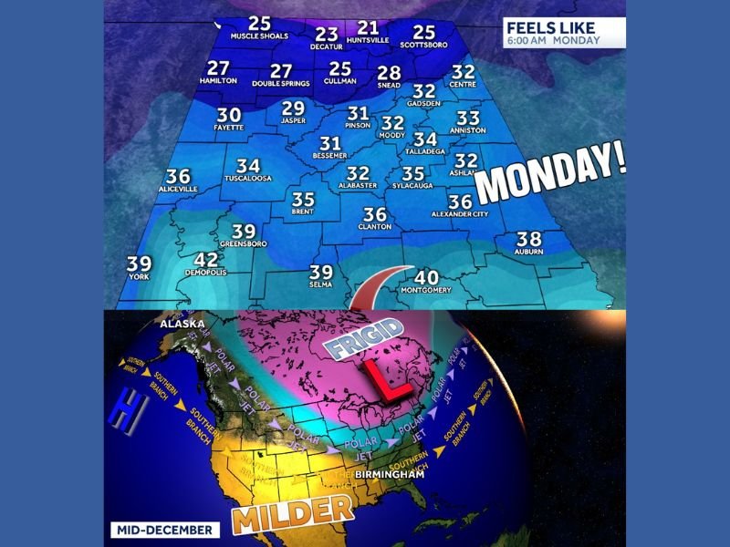
However, another cold front will arrive Sunday evening, bringing a chance of light rain and ushering in another round of cooler, drier air by Monday morning. Overnight lows will dip back into the upper 30s to low 40s, and Monday’s highs will struggle to get much above the upper 40s in Birmingham and surrounding areas.
“Even with some sunshine, we’ll still be running about 10 degrees below average for early December,” said meteorologist James Spann of ABC 33/40. “The colder air will settle in again to start the workweek.”
7-Day Forecast Snapshot
Friday: Morning rain with highs near 50°F, lows around 41°F.
Saturday: Rain possible in the south, highs around 54°F.
Sunday: Slight rain chance; high near 58°F, turning cooler late.
Monday: Mostly sunny, high near 48°F, low near 39°F.
Tuesday: Mostly sunny, high around 52°F.
Wednesday: Dry and warmer, highs near 58°F.
Thursday: Slight chance of rain, highs around 54°F.
While Sunday’s front will bring another cool spell, forecasters expect temperatures to rebound near 60°F by midweek before fluctuating again toward the end of next week.
Alaska Connection: What’s Driving the Chill
Meteorologists attribute Alabama’s recurring cold snaps this December to a frigid Arctic air mass linked to weather systems over Alaska. As those northern disturbances strengthen, they send surges of cold air southward into the central and southeastern United States.
This pattern — often referred to as an “Alaska connection” — has kept temperatures consistently below normal since late November. The effect has been amplified by persistent cloud cover and light rainfall across much of the Deep South.
Outlook: Cooler Start, Variable December Pattern Ahead
While Alabama residents can expect a chilly and occasionally damp start to the new week, longer-range outlooks suggest a pattern of wild temperature swings through mid-December. Forecasters caution that additional cold fronts are likely, interspersed with brief warmups between systems.
“We’re in one of those classic December patterns where the forecast can change quickly,” Spann added. “Don’t get too comfortable with any one temperature trend right now.”
By mid to late next week, Alabama should see another mild stretch before colder air potentially returns later in the month.
Stay updated with more local weather insights and advisories at NapervilleLocal.com.

I’ve lived in Naperville long enough to see how quickly our community changes — from new developments downtown to sudden shifts in our Midwest weather. Reporting on Naperville news and daily forecasts gives me the chance to keep neighbors informed about what really matters. My goal is simple: deliver clear, timely updates so you always know what’s happening in our city and what to expect from the skies above.