
Alabama Weather Models Show Mid-December Warm-Up Possible Before Cooler Pattern Returns Near Christmas
BIRMINGHAM, ALABAMA — After a string of chilly December days, weather models hint at a brief warm-up for Alabama beginning around December 14–15, with highs potentially reaching the 60s and low 70s in parts of central and southern Alabama before another cool-down likely arrives near Christmas.
While the change will feel pleasant compared to the recent cold, forecasters caution that the outlook remains fluid and subject to adjustment as mid-month approaches.
Mid-December Pattern Shift Brings Temporary Relief
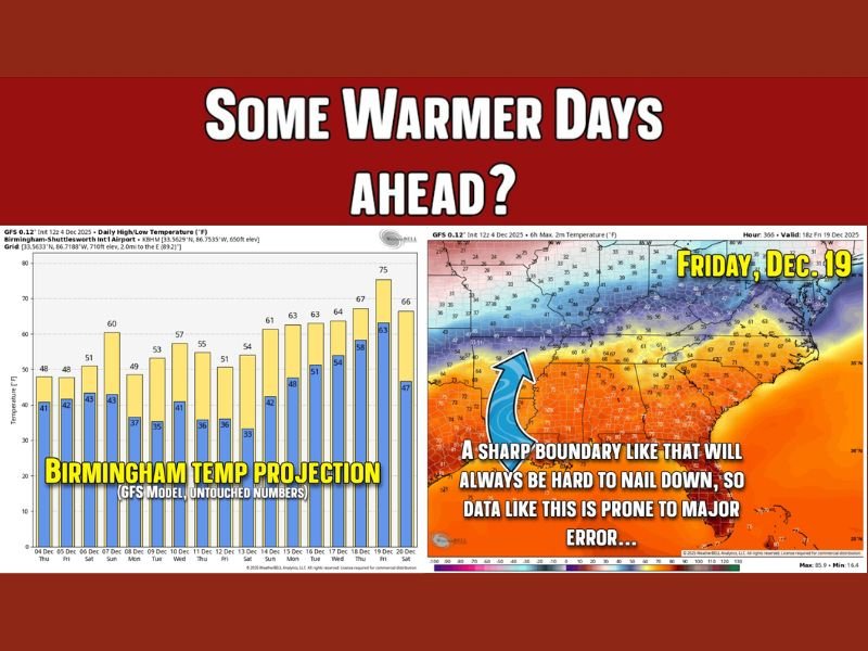
According to the GFS model temperature projections for Birmingham, daily highs are expected to rise from the upper 40s this week to near 60°F by Dec. 10, then gradually climb to mid-60s or even 70°F closer to December 15–19.
This warming trend aligns with a broader regional shift in upper-level flow, bringing milder air northward from the Gulf of Mexico. The warm pattern could also lead to a sharper temperature boundary, separating the southern warmth from lingering cold air to the north — a setup that can sometimes trigger rain or thunderstorms.
“It’s not a guarantee of a warm spell, but the signals are there,” meteorologist James Spann explained. “The middle of December looks less cold for a few days, especially in the Deep South. Just don’t expect it to last long.”
A Note on Forecast Models: Proceed With Caution
Forecasters emphasize that long-range models should be interpreted as trend indicators, not precise predictions. Temperature readings such as 75°F shown for Dec. 19 are highly uncertain and may shift by several degrees in either direction as the date nears.
In a detailed analysis, meteorologists compared these patterns to “college football rankings” — early projections that can change dramatically before the final outcome.
“Models are like guideposts,” Spann added. “They show us what might happen if conditions line up just right, but the atmosphere often throws in surprises. That’s why we track trends rather than specific numbers.”
The boundary between 70s in the South and 40s farther north will likely be narrow and prone to errors in model placement. Any deviation could drastically change outcomes for Alabama, especially regarding rainfall or thunderstorm chances.
What Comes After the Warm-Up?
Once the mid-month warmth fades, the current data suggests a return to cooler, more seasonable temperatures as the month progresses. By Christmas week, Alabama could shift back toward normal December cold, with highs in the 40s and lows in the 30s — though no major Arctic outbreak is currently indicated.
Meteorologists say this back-and-forth pattern is typical of early winter in the South, where short-lived warm spells often punctuate longer stretches of chill.
Key Takeaways for Alabama Residents
- Milder weather possible from Dec. 14–19, with highs reaching the 60s and 70s.
- Rain or thunderstorms may develop along a sharp boundary between warm and cold air.
- Colder air likely returns around Christmas week, bringing seasonal conditions.
- Long-range models should be viewed as general trends, not exact forecasts.
In short, Alabamians can look forward to a few days of mild, comfortable air before winter reasserts itself heading into the holidays.
Stay updated with verified local forecasts and weather alerts at NapervilleLocal.com.

I’ve lived in Naperville long enough to see how quickly our community changes — from new developments downtown to sudden shifts in our Midwest weather. Reporting on Naperville news and daily forecasts gives me the chance to keep neighbors informed about what really matters. My goal is simple: deliver clear, timely updates so you always know what’s happening in our city and what to expect from the skies above.