
Alabama Weather Shift Brings Cooler 60s and 70s Early Week Before 80s Return Across Birmingham, Montgomery, Huntsville
ALABAMA — After a stretch of unusually warm, almost summer-like weather, Alabama is now transitioning into a cooler and calmer pattern to start the week, with temperatures dropping noticeably before rebounding later.
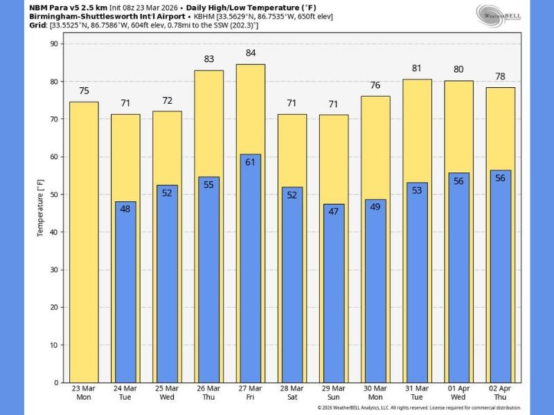
Forecast data shows a clear cooldown into the upper 60s and mid-70s today across much of the state, a sharp contrast from the widespread 80s experienced over the weekend.
Cooler Air Settles In Across the State
Communities across Alabama, including Birmingham, Montgomery, and Huntsville, are seeing a more seasonable feel return:
- Daytime highs: 68°F to 76°F today
- Overnight lows: dropping into the 40s and 50s
- Skies: Mostly sunny with dry conditions
This shift comes as slightly cooler air filters into the region, providing a break from the early-season heat.
Quiet Weather Pattern Dominates the Week
One of the most notable aspects of this forecast is just how calm and dry the pattern remains.
Meteorologists note:
- Only a small chance of isolated showers by midweek (Wednesday)
- Otherwise, rain-free conditions dominate statewide
- No significant storm systems expected through the week
This kind of quiet stretch is somewhat unusual for late March, which is typically part of Alabama’s more active severe weather season.
Temperatures Rebound Quickly by Late Week
While the cooldown is noticeable early on, it won’t last long.
By Thursday and Friday:
- Highs climb back into the low to mid 80s
- Warm, dry air returns across the region
- Sunshine continues to dominate
This creates a familiar spring pattern of fluctuating temperatures, but with minimal storm activity.
Weekend Outlook Stays Comfortable and Dry
Looking ahead, the upcoming weekend appears stable:
- Highs ranging from 66°F to 74°F
- Mostly sunny skies
- Cooler nights with comfortable conditions
This suggests ideal outdoor conditions without the threat of disruptive weather.
Longer-Term Pattern Shows Continued Dry Stretch
Forecast models indicate that this dry trend may persist into early April, delaying the next widespread rain or storm system.
While this reduces immediate severe weather risks, it also means:
- Limited rainfall for soil moisture
- Continued monitoring needed if dryness lingers
What This Means for Residents
- A brief return to cooler, more comfortable spring weather
- A quick shift back to above-normal warmth by late week
- Minimal rain chances, making for a predictable and stable forecast
Overall, Alabama is entering a quiet and manageable weather period, with no major hazards expected in the near term. Stay connected with NapervilleLocal.com for continued updates on shifting weather patterns across the Midwest and southern United States.

I’ve lived in Naperville long enough to see how quickly our community changes — from new developments downtown to sudden shifts in our Midwest weather. Reporting on Naperville news and daily forecasts gives me the chance to keep neighbors informed about what really matters. My goal is simple: deliver clear, timely updates so you always know what’s happening in our city and what to expect from the skies above.