
Alabama Weather Shift: Mid-December Warmup to Bring Relief After Early Cold Snap Across the South
BIRMINGHAM, ALABAMA — After several days of chilly, below-normal temperatures, a brief mid-December warmup appears on the horizon for Alabama and much of the southern United States. Forecast models indicate a shift toward a zonal upper-air pattern around December 14–16, bringing milder air across the region while colder Arctic air retreats northward into the upper Midwest.
At 11 a.m. Friday, temperatures in Birmingham were still sitting near 41°F, but sunshine breaking through the clouds was expected to lift afternoon highs into the mid-to-upper 40s. This follows a week of colder-than-normal weather across the Deep South, where many residents woke up to frosty mornings and steady rain.
Meteorologists say this warming phase — what some are calling a “mid-December intermission” — will serve as a short break before winter’s next push of cold air returns later in the month.
Warmer Air to Build Across the South
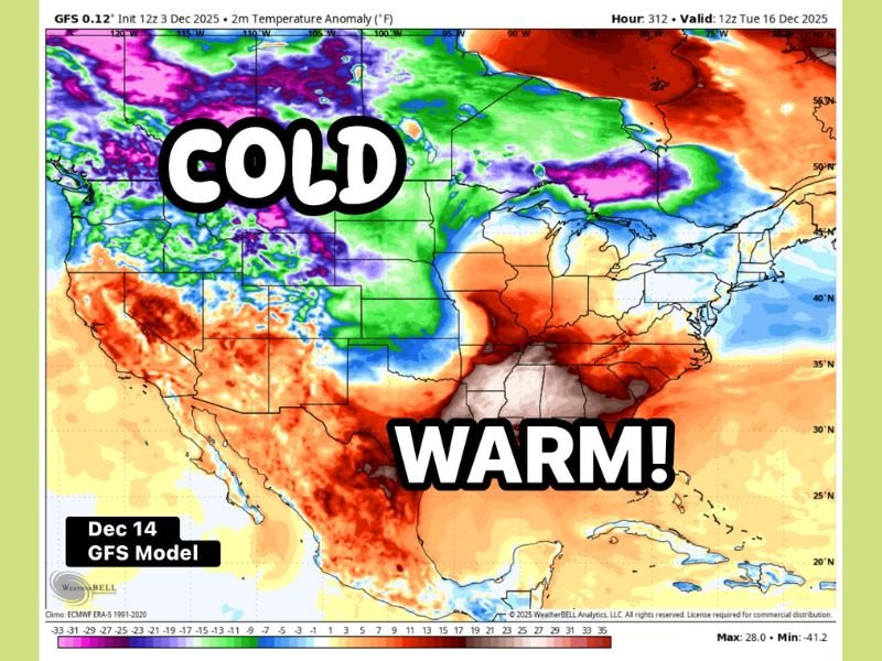
The GFS (Global Forecast System) model projection for December 14 shows a clear temperature contrast across the nation:
- A warm surge covering the Deep South, lower Mississippi Valley, and parts of the Southeast, with anomalies up to 10–15°F above average.
- A cold pool persisting across the northern Plains, Great Lakes, and upper Midwest, where temperatures will stay 10–20°F below normal.
In Alabama, temperatures are expected to rebound into the mid-50s and possibly near 60°F for parts of central and southern regions, offering a reprieve from the recent chill. Areas to the north — including Tennessee and Kentucky — should also see milder highs compared to the early December cold pattern.
“Zonal Flow” to Bring a Temporary Pattern Change
The shift comes as upper-level winds flatten into a west-to-east (zonal) flow, reducing the frequency of deep cold air intrusions from Canada. This pattern allows the southern states to enjoy more moderate air and increased rain chances rather than wintry precipitation.
“If it’s gotten too cold too quickly for you, this is your break,” forecasters noted. “By mid-December, the setup will favor milder temperatures before another likely cooldown late in the month.”
Rain remains a recurring theme, however. The new pattern could lead to frequent light rain events across the South, with occasional cloud breaks allowing mild afternoons followed by cool, damp nights.
Snow Chances Remain Very Low for Alabama
While portions of the Midwest and Great Lakes will continue to deal with snow showers from Alberta Clippers and lake-effect systems, Alabama’s forecast remains too warm for any substantial wintry activity.
At most, forecasters say residents might see a few isolated snowflakes trailing behind certain rain systems — but there’s no realistic chance of snow accumulation in the state at this time.
“This is shaping up to be more of a cold rain pattern for Alabama,” meteorologists said. “The setup just isn’t favorable for impactful snow at this point in the season.”
Outlook for the Rest of December
After the brief warmup around December 14–16, the long-range models hint that colder conditions may return closer to Christmas week as Arctic air tries to push back into the central United States.
Until then, expect a stretch of seasonable-to-mild days punctuated by intermittent showers — a temporary pause in winter’s early grip.
Residents are encouraged to stay weather-aware as the pattern evolves and to keep an eye on updates from the National Weather Service in Birmingham.
For the latest Alabama and Midwest weather developments, visit NapervilleLocal.com for continuing coverage and updates.

I’ve lived in Naperville long enough to see how quickly our community changes — from new developments downtown to sudden shifts in our Midwest weather. Reporting on Naperville news and daily forecasts gives me the chance to keep neighbors informed about what really matters. My goal is simple: deliver clear, timely updates so you always know what’s happening in our city and what to expect from the skies above.