
Alabama Weather Update Shows Cold Front Bringing 70s to Birmingham, Huntsville, Montgomery Before Tuesday Showers and Late Week Cooldown
ALABAMA — A changing weather pattern is setting up across Alabama as a cold front moves through today, bringing a return to more seasonable temperatures, followed by rain chances Tuesday and another cooldown heading into the weekend.
After recent warmth, today marks a transition day with noticeable shifts in wind and temperatures.
Cooler but Comfortable Conditions Today
The approaching cold front is already influencing conditions statewide, with highs settling into the 70s across cities like Birmingham, Huntsville, and Montgomery.
Key impacts today include:
- A return to milder, more typical late-March temperatures
- Dry conditions with no rain expected
- Increasing north winds developing through the afternoon
This shift will make the air feel fresher compared to the recent stretch of warmer weather.
Overnight Temperatures Drop Sharply
Behind the front, cooler air filters in quickly tonight:
- Upper 40s across northern Alabama
- Low 50s across southern areas
Clear skies and lighter winds overnight will allow temperatures to fall efficiently, creating a crisp start to Tuesday morning.
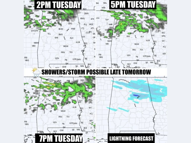
Rain Chances Return Tuesday Afternoon and Evening
While Tuesday begins dry, the next weather system arrives later in the day.
Forecast models show:
- Scattered showers developing by Tuesday afternoon (around 2 PM onward)
- Activity becoming more widespread by late afternoon into the evening (5 PM–7 PM timeframe)
- A chance for isolated thunderstorms, though severe weather is not expected
Rain will continue into early Wednesday morning, but coverage will vary, meaning not all areas will see significant rainfall.
Limited Rainfall Expected Overall
This system is not expected to bring heavy or widespread rain:
- Rainfall will be spotty and uneven
- Some areas may receive only light showers
- It could still be one of the last meaningful rain chances for the remainder of March
This raises some concern about longer-term dryness if additional systems do not develop soon.
Another Cold Front Late Week
Looking ahead, another cold front is expected to arrive Friday night, bringing another shift in conditions:
- A noticeable cooldown into Saturday morning
- Overnight lows dipping into the upper 30s to low 40s
- Potential for chilly early morning conditions, though frost risk remains uncertain
What Residents Should Expect
- Enjoy a dry and mild Monday with highs in the 70s
- Prepare for scattered showers and possible storms Tuesday afternoon and evening
- Expect cooler temperatures returning by the weekend
Overall, Alabama is entering a typical spring transition pattern, with quick swings between warm and cool periods and limited but important rain opportunities. Stay with NapervilleLocal.com for continued updates on weather patterns impacting the Midwest and southern United States.

I’ve lived in Naperville long enough to see how quickly our community changes — from new developments downtown to sudden shifts in our Midwest weather. Reporting on Naperville news and daily forecasts gives me the chance to keep neighbors informed about what really matters. My goal is simple: deliver clear, timely updates so you always know what’s happening in our city and what to expect from the skies above.