
Alabama Winter Storm Shows Razor-Thin Temperature Gradient as Ice Threat Targets The Shoals While Spring-Like Warmth Surges South Sunday
UNITED STATES — A developing storm system set to impact the southern United States this weekend is showing extraordinary temperature contrasts across Alabama, creating a razor-thin margin between ice and rain as the system evolves Sunday afternoon into Sunday night.
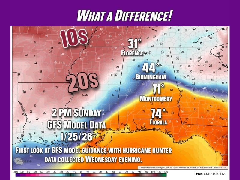
New data collected Wednesday evening from a NOAA Hurricane Hunter mission sampling the Pacific portion of the storm confirms a northward shift in the system, sharpening the threat of freezing rain and ice accumulation in northwest Alabama while much warmer air surges just to the south.
Hurricane Hunter Data Confirms Storm Shift and Sharpens Ice Risk
The latest GFS model guidance, incorporating fresh Hurricane Hunter observations, confirms a track adjustment that forecasters anticipated earlier in the day. This adjustment places the greatest ice risk squarely across northwestern Alabama, particularly near The Shoals.
Forecasters note that while the GFS has known limitations, the consistency of the shift across updated data strengthens confidence that ice will be the dominant concern, not snow, in this zone.
Areas farther south remain under a Winter Storm Watch, but with lesser impacts expected due to warmer surface temperatures.
Extreme Temperature Gradient Sets the Stage for Dangerous Conditions
The most striking signal from the data is the dramatic temperature contrast expected Sunday afternoon, illustrating just how narrow the transition zone will be.
Key temperature projections at 2 PM Sunday include:
- Near-freezing conditions around 31°F in Florence
- Mid-40s around 44°F in Birmingham
- Spring-like warmth near 71°F in Montgomery
- Summer-like readings around 74°F near Florala
- 20s and lower 30s just northwest of The Shoals
- 10s across portions farther northwest
This represents a nearly 30-degree difference between Birmingham and Montgomery and more than a 40-degree difference from the Florida border to The Shoals, an exceptionally tight gradient for a winter system.
Why Ice Is the Primary Threat, Not Snow
With temperatures hovering just below freezing in northwest Alabama while warm air pushes in aloft, conditions become ideal for freezing rain rather than accumulating snow.
Forecasters emphasize that even small temperature changes of one or two degrees could significantly alter impacts, making this system especially sensitive and difficult to forecast precisely.
Ice accumulation, even if light, poses risks of:
- Power outages
- Tree damage
- Hazardous travel
- Infrastructure stress
Timing and Impact Window Remain Critical
The highest-risk window appears to be Sunday afternoon through Sunday night, when warm and cold air masses will be actively competing across the region.
Because the storm is still evolving, forecasters stress that impacts may shift slightly north or south, but confidence is growing that northwest Alabama remains the most vulnerable area for ice.
Residents in and near the transition zone should be prepared for rapid weather changes over short distances, with rain, ice, and mild conditions all occurring within the same state at the same time.
Why This Storm Demands Close Monitoring
Meteorologists describe this setup as a classic high-impact, low-margin event, where forecast precision matters more than raw totals.
The combination of:
- Confirmed storm track adjustment
- Hurricane Hunter data
- Extreme temperature gradients
- Ice-favorable thermal profiles
makes this system one that warrants close attention through the weekend, especially for those in northwest Alabama.
For continued expert analysis, evolving forecasts, and regional weather updates explained clearly, stay connected with NapervilleLocal.com.

I’ve lived in Naperville long enough to see how quickly our community changes — from new developments downtown to sudden shifts in our Midwest weather. Reporting on Naperville news and daily forecasts gives me the chance to keep neighbors informed about what really matters. My goal is simple: deliver clear, timely updates so you always know what’s happening in our city and what to expect from the skies above.