
Alabama’s Spring-Like 70s and 80° Warmth to Be Replaced by Weekend Cold Front, Showers, and Early-Week Freeze Risk
ALABAMA — A stretch of spring-like warmth is gripping much of the state this week, with temperatures climbing well above seasonal averages before a noticeable pattern shift arrives by the weekend.
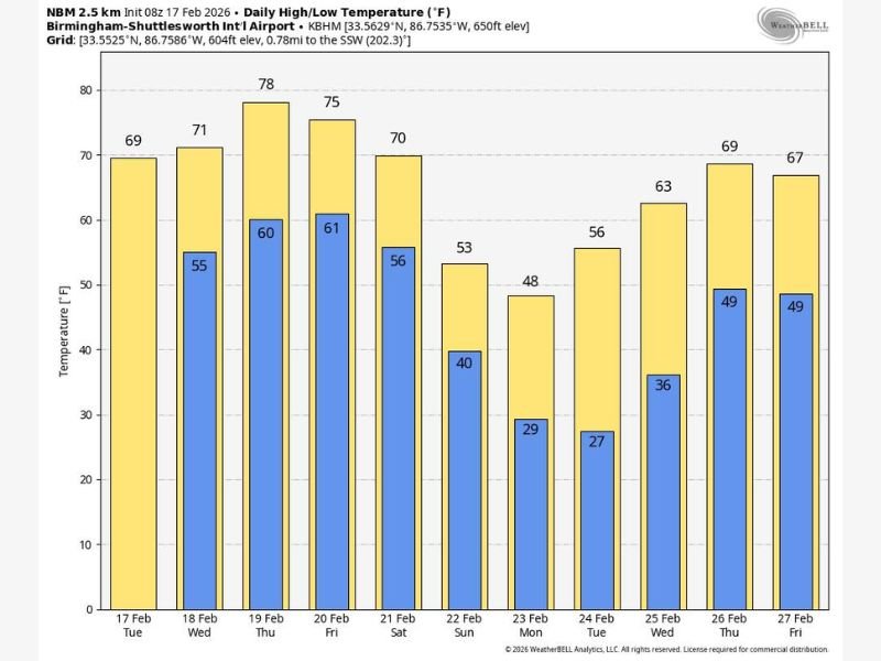
Forecast data centered around Birmingham-Shuttlesworth International Airport shows highs pushing into the upper 70s by Thursday, peaking near 78 degrees. Wednesday is expected to reach the low 70s, followed by mid-70s warmth Friday. Even Tuesday begins comfortably mild in the upper 60s.
Across South Alabama, some communities could flirt with the 80-degree mark Thursday afternoon — a remarkable jump for mid-February. Sunshine will dominate much of this stretch, creating ideal outdoor conditions statewide. Morning lows will also trend mild through Friday, mainly in the mid-50s to low 60s, reinforcing the early-spring feel.
Moisture Returns as Front Approaches Late Week
The quiet pattern begins to shift after Thursday. Increasing moisture will bring the chance for a few isolated showers as early as Wednesday and Thursday. While rainfall coverage should remain limited at first, a more organized system develops by Friday.
A cold front drifting toward the Alabama–Tennessee state line will likely stall temporarily, increasing the chance for showers and thunderstorms Friday and Friday night — particularly across the northern half of Alabama. Forecasters note the atmosphere may become somewhat unstable. While this is not currently projected as a classic widespread severe weather setup, a stronger storm or two cannot be ruled out.
Saturday will likely feature more widespread showers and a few thunderstorms statewide as the front slowly pushes southward. Model guidance suggests southern counties may see the best chance of steady rainfall by Saturday afternoon. Despite the rain chances, afternoon highs are still expected to reach the 70s Friday and Saturday, especially across central and southern Alabama.
Sharp Cooldown Arrives Sunday
The more significant change arrives late weekend. Colder, drier air settles in Sunday, sending highs tumbling into the 50s for much of the northern two-thirds of Alabama. That represents a drop of roughly 20 degrees compared to Thursday’s peak warmth.
Overnight lows will respond quickly. By Monday morning, temperatures across northern and central Alabama could dip to around 29 to 40 degrees depending on location. Birmingham is projected to fall into the upper 20s by early next week, while surrounding areas may see widespread 30s.
Freeze Threat Expands Early Next Week
By Tuesday morning, freeze conditions may extend farther south. Forecast guidance suggests parts of central and even southern Alabama could experience freezing temperatures, particularly in low-lying and rural areas. North Alabama is expected to struggle to climb out of the 40s Monday afternoon before moderating slightly midweek.
The cold snap appears brief, however. By Thursday of next week, highs rebound into the upper 60s and low 70s once again. Additional showers and thunderstorms may return late next week as the active pattern continues.
This week showcases a dramatic February swing for Alabama — from near-80-degree warmth under sunny skies to rain chances, then back to winter-like chill and potential freezes within just a few days.
Residents are encouraged to enjoy the mild weather early in the week, but also prepare for wet conditions Friday and Saturday and protect sensitive plants ahead of the early-week freeze risk. For continued updates on shifting weather patterns across the South and how they could impact travel or family plans, stay connected with NapervilleLocal.com.

I’ve lived in Naperville long enough to see how quickly our community changes — from new developments downtown to sudden shifts in our Midwest weather. Reporting on Naperville news and daily forecasts gives me the chance to keep neighbors informed about what really matters. My goal is simple: deliver clear, timely updates so you always know what’s happening in our city and what to expect from the skies above.