
Arctic Air Surges Into Texas Faster Than Forecast, Raising Risk of Widespread Freezing Rain Across Southeast Texas Into Sunday
TEXAS — A powerful surge of Arctic air is pouring into West Texas and the Texas Panhandle far faster and colder than forecast, raising serious concerns that freezing rain and icy conditions could be more severe and longer-lasting across Southeast Texas than many computer models currently indicate. Meteorologists warn that models are underestimating just how cold this air mass is, increasing the risk of an icy mess that may linger into Monday.
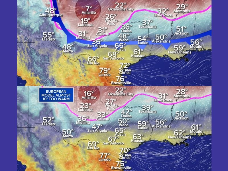
Reality Already Colder Than Computer Models
Observed temperatures Friday evening revealed a significant forecast bust, especially in the Panhandle.
At 6 PM Friday:
- Amarillo dropped to 7°F
- The European model had forecast 16°F
- The same model did not predict 7°F until late Sunday night
This means the cold air is outrunning forecasts by nearly two days, a critical error when freezing rain potential is involved.
Why This Matters for Southeast Texas
The Arctic air currently in West Texas and the Panhandle is the same air mass expected to push southeast Saturday night into Sunday morning.
Several models still suggest that:
- Houston may remain above freezing during rain
- Surface temperatures may be marginal
However, real-world observations suggest those assumptions may be wrong, as the cold air is proving stronger, denser, and more aggressive than expected.
Freezing Rain Risk Increasing
Even colder forecast guidance already shows freezing rain across parts of Southeast Texas, yet those same models still appear too warm at the surface.
This raises the possibility of:
- Rain freezing on contact
- Ice accumulation on roads, bridges, trees, and power lines
- Travel becoming dangerous quickly Sunday morning
Forecasters now caution that freezing rain could remain locked to the ground through Monday afternoon if temperatures fail to rebound.
Cities and Regions of Concern
Based on the cold air trajectory and temperature errors, heightened concern includes:
- Houston metro area
- Coastal Plains of Southeast Texas
- Areas north and west of the immediate coast
- Locations away from marine influence
Farther inland locations are more vulnerable to prolonged icing, especially where cold air becomes trapped near the surface.
Model Errors Still Ongoing
Meteorologists note that even the colder-performing models remain warmer than reality, which suggests:
- Ice potential may be underplayed
- Timing of freezing conditions could arrive earlier
- Impacts may last longer than currently forecast
This is a classic setup where surface observations outperform model projections, and those situations often lead to worse-than-expected ice impacts.
What Residents Should Prepare For
Residents across Southeast Texas should prepare for:
- Icy roads Sunday morning
- Possible power outages
- Hazardous travel lasting into Monday
- Frozen surfaces persisting longer than expected
This is not expected to be a quick overnight event — lingering cold may prevent meaningful melting until Monday afternoon or later.
Forecast Still Being Refined
Forecasters will continue refining the forecast over the next 24 hours as more data arrives, but confidence is growing that cold air is being underestimated, which historically favors more significant ice impacts. This type of setup has produced major disruptions in past Texas winter events, even when initial forecasts appeared manageable.
Stay alert, limit unnecessary travel, and monitor evolving conditions closely. For continued coverage and detailed breakdowns of major winter weather threats across the country, follow updates at NapervilleLocal.com.

I’ve lived in Naperville long enough to see how quickly our community changes — from new developments downtown to sudden shifts in our Midwest weather. Reporting on Naperville news and daily forecasts gives me the chance to keep neighbors informed about what really matters. My goal is simple: deliver clear, timely updates so you always know what’s happening in our city and what to expect from the skies above.