
Arctic Blast Expected to Hit the South on December 3, Sending Temperatures Plummeting Across Texas, Mississippi, and Georgia
DALLAS, TEXAS — A powerful Arctic air mass is forecast to plunge deep into the South next week, bringing a sudden and dramatic drop in temperatures across Texas, Mississippi, Alabama, Louisiana, Georgia, and parts of Tennessee.
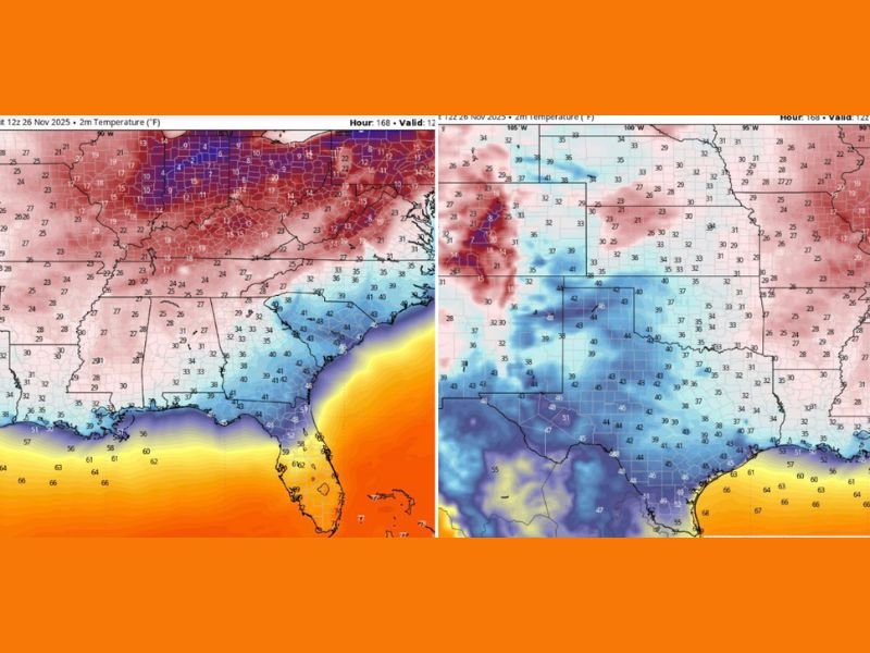
Forecast models suggest that by December 3, much of the region will wake up to temperatures in the 20s and low 30s, marking one of the most significant early-winter cold outbreaks so far this season.
Model Data Suggests Widespread Freeze Across the South
According to early GFS model runs, cold air will surge southward from the Central Plains late Tuesday, reaching Texas overnight and spreading across the Southeast by Wednesday morning. Cities like Dallas, Birmingham, Atlanta, and Jackson are expected to see morning lows in the 20s and 30s, while Houston could struggle to stay above the low 40s.
Meteorologists caution that this model run is not yet an official forecast, but the potential cold stretch could break daily temperature records if verified.
“We’re looking at a setup where nearly the entire South—from Texas to the Carolinas—could see freezing temperatures,” one forecaster noted. “If this verifies, it’ll feel like the Arctic just booked a vacation in the Gulf states.”
Deep Freeze to Follow Across the Southeast
The cold air mass will expand eastward, dropping temperatures throughout the Deep South and Gulf Coast.
- Mississippi, Alabama, and Georgia: Lows in the upper 20s to low 30s
- Louisiana and Texas: 20–25°F temperature drops compared to this week
- Florida Panhandle: Upper 30s to low 40s, with brisk north winds
This pattern will also extend into Tennessee and the lower Midwest, where overnight lows could dip into the teens.
The cold air intrusion is being driven by a deep trough in the jet stream that will funnel Arctic air directly south. Winds behind the front are expected to remain gusty, making it feel several degrees colder.
Early Warnings for Residents
Meteorologists are urging residents across the region to prepare for a sudden shift in weather patterns — particularly those in areas unaccustomed to early-season freezes.
Homeowners should protect pipes, pets, and plants, and drivers are advised to monitor travel conditions closely in the days ahead.
“Don’t underestimate this one,” weather analysts said. “We’ve got readings in the 20s showing up across states that were just in the 70s a week ago.”
A Wake-Up Call for the Gulf Coast
For Houston, New Orleans, and Gulfport, this system could bring the coldest air since last winter, with highs barely reaching the 50s on December 3. Meanwhile, north Texas and northern Mississippi could wake up to frost and icy wind chills in the teens.
The early December chill will follow an already cold Thanksgiving week across parts of the South, setting up a colder-than-normal start to winter.
When to Expect the Chill
- Saturday, Nov. 30: Front develops across the Central Plains
- Sunday, Dec. 1: Cold air reaches Oklahoma and northern Texas
- Monday, Dec. 2–Tuesday, Dec. 3: Deep freeze expands across the Southeast
- Wednesday, Dec. 4: Coldest morning temperatures likely
Meteorologists emphasize that while the forecast could evolve, the pattern is consistent with a strong early-winter outbreak.
Stay ahead of developing cold-weather alerts, forecast updates, and safety tips by visiting NapervilleLocal.com for continued coverage.

I’ve lived in Naperville long enough to see how quickly our community changes — from new developments downtown to sudden shifts in our Midwest weather. Reporting on Naperville news and daily forecasts gives me the chance to keep neighbors informed about what really matters. My goal is simple: deliver clear, timely updates so you always know what’s happening in our city and what to expect from the skies above.