
Arctic Blast to Grip Minnesota, Wisconsin, and Illinois With Dangerous -30°F Wind Chills by Thursday Morning
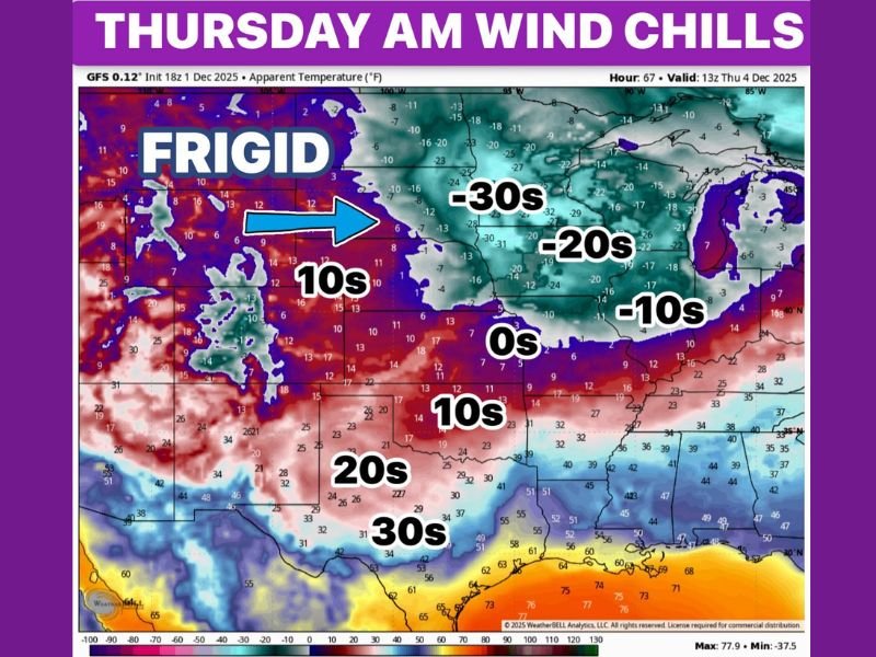
ILLINOIS — A powerful Arctic air mass is set to plunge across Minnesota, Wisconsin, and Illinois late Wednesday night into Thursday morning, bringing dangerously cold wind chills between -20°F and -30°F across much of the Upper Midwest. Meteorologists warn that exposure to these conditions could lead to frostbite within 10 minutes on uncovered skin.
According to weather models, this outbreak is part of a polar vortex surge pushing southward into the central United States. Combined with existing snow cover across northern states, actual air temperatures are expected to fall well below zero, while strong north winds will make it feel even colder.
Brutal Wind Chills Across the Upper Midwest
The coldest wind chills will strike Minnesota, northern Wisconsin, and parts of Iowa, where readings between -25°F and -35°F are expected early Thursday morning. In northern Illinois, including the Chicago suburbs, wind chills could range from -10°F to -20°F, creating hazardous travel and commuting conditions.
“This is the kind of cold that can freeze exposed skin in under 10 minutes,” forecasters said, emphasizing the need for residents to bundle up and limit outdoor activity.
Minneapolis, Duluth, Milwaukee, and Rockford are all expected to experience the harshest impacts from the Arctic blast, with dangerous cold lasting through much of Thursday morning before slightly moderating in the afternoon.
Cold Spreads South Toward Texas and the Central Plains
The frigid air won’t stop at the Great Lakes. By Thursday afternoon, a second wave of cold air will expand southward, reaching the Central Plains and northern Texas. Temperatures in Oklahoma and north Texas could drop into the 40s, with reports of light freezing drizzle possible as the Arctic air collides with lingering moisture.
Meanwhile, across Nebraska, Kansas, and Missouri, morning lows are forecast to stay in the single digits with biting winds, keeping “feels-like” temperatures near zero.
Expected Temperatures and Impacts
- Minnesota: -10°F actual temperatures, wind chills near -30°F
- Wisconsin: -5°F to -10°F, wind chills from -20°F to -25°F
- Illinois: Single-digit lows, wind chills from -10°F to -20°F
- Iowa: Subzero lows, wind chills as cold as -25°F
- Texas Panhandle: Highs only in the 40s with light freezing rain possible
Safety Precautions
Officials urge residents to take extra precautions:
- Limit time outdoors and wear insulated gloves, hats, and face coverings.
- Bring pets inside and check on elderly neighbors.
- Prevent frozen pipes by letting faucets drip overnight.
- Use space heaters safely to avoid carbon monoxide poisoning or fires.
Looking Ahead
The Midwest’s extreme cold is expected to ease by Friday afternoon, though temperatures will remain below normal through the weekend. Another round of light snow or wintry mix could return early next week as the jet stream remains active.
For continuing winter weather coverage across the Midwest, follow updates at NapervilleLocal.com.

I’ve lived in Naperville long enough to see how quickly our community changes — from new developments downtown to sudden shifts in our Midwest weather. Reporting on Naperville news and daily forecasts gives me the chance to keep neighbors informed about what really matters. My goal is simple: deliver clear, timely updates so you always know what’s happening in our city and what to expect from the skies above.