
Arctic Temperatures Surge Up to 40 Degrees Above Normal, Triggering Global Weather Imbalances and Heightened Climate Concerns
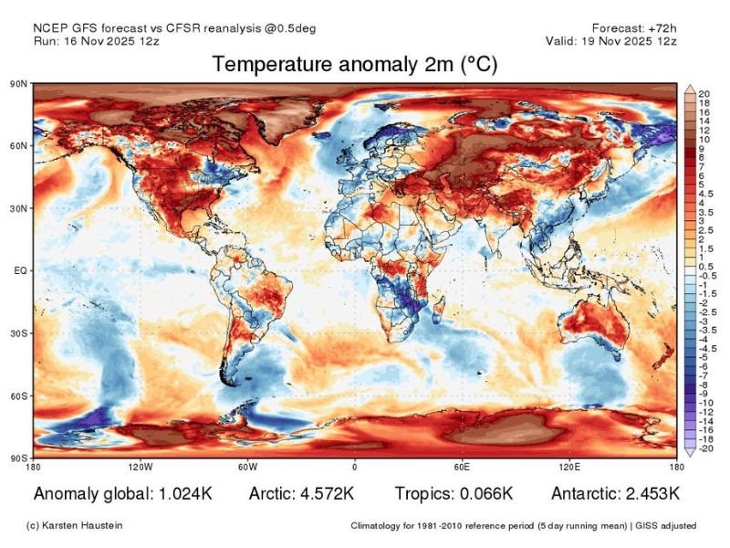
ARCTIC REGION — New global climate and temperature anomaly data reveals that parts of the Arctic are running nearly 40°F above normal, a dramatic spike that climate scientists say is consistent with long-term projections of rapid polar warming. The new 3-day forecast map shows the Arctic warming at roughly 3–4 times the global average, a phenomenon known to amplify weather extremes across the Northern Hemisphere.
Why the Arctic Is Warming So Quickly
Climate researchers have long warned that the Arctic would warm faster than the rest of the planet, primarily due to the loss of reflective sea ice and the increased absorption of solar energy by open ocean waters. According to the commentary accompanying the data, this warming trend was predicted decades ago in early climate models and is now playing out in real-time.
Several key drivers are contributing to the extreme warmth:
- Rapid loss of sea ice, weakening the cooling effect normally provided by frozen ocean surfaces
- Amplified atmospheric feedback loops, where warming reduces ice, which leads to even more warming
- Higher global baseline temperatures, boosting natural seasonal variations
- Teleconnection patterns like La Niña, which influence how warmth and cold are distributed across the globe
The map indicates an Arctic anomaly of +4.572K, far above the global 1.024K anomaly.
How Arctic Warming Disrupts Global Weather Patterns
Meteorologists emphasize that nothing in weather exists in isolation. When the Arctic becomes significantly warmer, it disrupts the jet stream, destabilizes atmospheric patterns, and increases the odds of extreme weather in mid-latitude regions, including the United States.
Experts explain that:
- The Arctic’s relative warmth can cause blocking patterns, where weather systems stall or loop unusually.
- Extreme warmth in high latitudes increases the chance of intense storms, flash floods, severe cold outbreaks elsewhere, and prolonged unusual temperature swings.
- When natural variability (like La Niña) overlaps with anthropogenic warming, the intensity of anomalies increases, making extreme events more noticeable and more impactful.
This combination of natural oscillations and human-driven warming is not mutually exclusive—both interact and often amplify each other.
What the Forecast Map Shows for the Coming Days
The temperature anomaly map from Karsten Haustein’s forecast, valid for November 19, shows striking global contrasts:
- Deep red zones across the Arctic indicating extraordinary warmth
- Large warm anomalies across parts of Canada, Russia, Scandinavia, and the North Pacific
- Cooler-than-normal pockets appearing in parts of the Southern Hemisphere
- Broad warmth across continental land masses consistent with climate-driven baseline increases
The data highlights a world where baseline global temperatures are rising, causing natural variations to produce increasingly pronounced effects.
Scientists say the Arctic’s abrupt warming this week is another example of long-anticipated climate dynamics now unfolding more visibly and more frequently.
For continued coverage of global climate trends, extreme weather forecasts, and how these shifts may affect the Midwest, stay connected with NapervilleLocal.com for the latest updates.

I’ve lived in Naperville long enough to see how quickly our community changes — from new developments downtown to sudden shifts in our Midwest weather. Reporting on Naperville news and daily forecasts gives me the chance to keep neighbors informed about what really matters. My goal is simple: deliver clear, timely updates so you always know what’s happening in our city and what to expect from the skies above.