
Arkansas, Mississippi, and Alabama Storm Alert: Very Large Hail and Possible Tornadoes Expected as Severe Weather Develops Across the Deep South
ARKANSAS — Severe thunderstorms are expected to develop across parts of the Deep South today, with meteorologists warning that very large hail and isolated tornadoes could occur across Arkansas, Mississippi, and Alabama as a developing storm system moves through the region.
Forecast data indicates that the storms could form in clusters as warm air surges northward and an impulse of atmospheric energy moves across the area. While widespread tornado activity is not expected, conditions may still allow a few stronger storms capable of producing damaging hail and possibly a tornado or two.
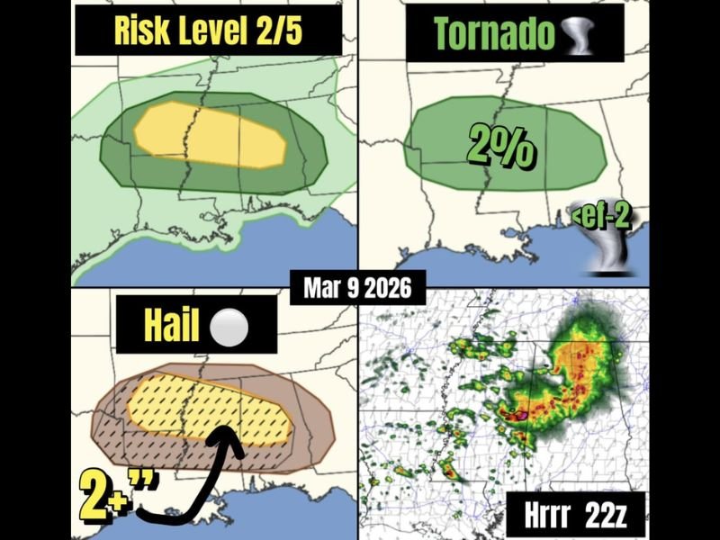
Risk Level 2 of 5 for Severe Weather
The current forecast places parts of the region under a Level 2 out of 5 severe weather risk, meaning scattered severe storms are possible.
This risk area stretches across portions of Arkansas, northern Mississippi, and northern Alabama, where storms may organize during the afternoon and evening hours.
Meteorologists say the main driver of the storms will be warm air advection, which occurs when warm, moisture-rich air moves northward and fuels thunderstorm development.
Very Large Hail Expected to Be the Primary Threat
While tornado potential exists, forecasters say the largest concern will likely be large to very large hail. Some storms could produce hailstones larger than two inches in diameter, especially if isolated supercells develop within the broader storm clusters. Hail of that size can cause significant damage to vehicles, roofs, crops, and outdoor property, making it one of the more dangerous storm hazards expected with this system.
Isolated Tornado Risk Also Present
Even though hail is expected to be the dominant threat, the storm environment may still support a few isolated tornadoes, particularly if a rogue supercell forms.
Forecast projections suggest a roughly 2 percent tornado probability across the region, which means tornadoes are possible but not expected to be widespread. If a tornado does develop, meteorologists say it could potentially reach EF-2 strength, depending on storm organization and wind dynamics.
Storm Clusters Could Form Later Today
Weather model simulations indicate that storms may develop into multiple clusters across Arkansas, Mississippi, and Alabama during the afternoon and evening hours.
These clusters could bring bursts of heavy rain, lightning, large hail, and gusty winds as they move across the region. The strongest storms will likely form where instability, moisture, and wind shear overlap most effectively.
Residents Should Monitor Weather Conditions
Even though this is not expected to be a widespread outbreak, the possibility of large hail and isolated tornadoes means residents should stay alert to changing weather conditions throughout the day.
Storms capable of producing severe weather can sometimes develop quickly, especially when warm air and atmospheric energy combine in favorable conditions.
Residents across Arkansas, Mississippi, and Alabama are encouraged to monitor local forecasts and be prepared to take shelter if severe thunderstorm or tornado warnings are issued later today.

I’ve lived in Naperville long enough to see how quickly our community changes — from new developments downtown to sudden shifts in our Midwest weather. Reporting on Naperville news and daily forecasts gives me the chance to keep neighbors informed about what really matters. My goal is simple: deliver clear, timely updates so you always know what’s happening in our city and what to expect from the skies above.