
Arkansas, Tennessee, Mississippi and Alabama Face Possible Morning Freeze Threat February 23–24 After Sudden Warm-to-Cold Shift
UNITED STATES — After a stretch of unseasonably warm temperatures across the southern United States, new forecast guidance is hinting that colder air could quickly sweep in behind a late-week system, bringing the possibility of a morning freeze threat around February 23–24.
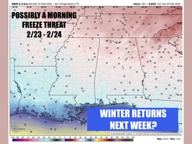
Model data valid for the morning of Tuesday, February 24, shows temperatures potentially dipping into the mid-20s to lower 30s across portions of Arkansas, northern Mississippi, northern Alabama, and Tennessee. While this does not appear to be a full-scale polar outbreak, it could be enough to produce patchy frost and light freeze conditions in some areas.
Where the Coldest Air Could Settle
The projected temperature map highlights:
- Mid-20s across northern Tennessee
- Upper 20s across northern Mississippi and northern Alabama
- Upper 20s to near 30 across parts of Arkansas
- Low 30s stretching southward toward central Alabama and Georgia
Farther south, along the Gulf Coast, readings are expected to remain milder, generally in the mid-30s to low 40s.
The setup suggests a quick push of cooler, drier air rather than a prolonged winter pattern.
Why the Timing Matters
The potential freeze risk follows a period of warmer-than-average weather expected earlier in the week. Rapid temperature swings during late February can be impactful, especially for:
- Early budding plants
- Outdoor agriculture
- Sensitive landscaping
Even a brief drop below freezing during early morning hours can cause localized damage if vegetation has already responded to spring-like warmth.
Not a Polar Plunge — But Worth Watching
Forecasters emphasize this does not resemble a major Arctic blast. Instead, it appears to be a quick surge of colder air behind a departing system.
There remains significant time for the forecast to adjust. Temperature projections several days out can shift north or south depending on storm track and timing. Slight changes in wind direction or cloud cover could also influence how cold it gets during the early morning hours.
Midwest Outlook
At this stage, the highlighted freeze signal is concentrated across the Deep South and lower Mid-South. Illinois, including the Naperville area, is not within the core freeze anomaly zone shown in this projection.
However, late February often brings temperature volatility across much of the country, so broader pattern shifts remain possible. For continued weather updates and national forecast analysis, follow NapervilleLocal.com.

I’ve lived in Naperville long enough to see how quickly our community changes — from new developments downtown to sudden shifts in our Midwest weather. Reporting on Naperville news and daily forecasts gives me the chance to keep neighbors informed about what really matters. My goal is simple: deliver clear, timely updates so you always know what’s happening in our city and what to expect from the skies above.