
Atmospheric River Aims at Washington as State Faces Renewed Flooding Threat, Power Outages, and Already Saturated Ground
WASHINGTON — A powerful atmospheric river stretching hundreds of miles across the Pacific Ocean is advancing toward the Washington coast, raising concerns for new flooding, infrastructure strain, and dangerous travel conditions. The incoming storm system follows a series of destructive weather events that have already left the region vulnerable.
Washington continues to face broken levees, widespread flooding, washed-out roads, and damaged infrastructure from earlier storms. Nearly 400,000 residents remain without power, with hurricane-force wind gusts having toppled trees and power lines, complicating statewide recovery efforts. As emergency crews work to restore utilities, the approaching storm threatens to worsen the situation.
Ground Already Saturated as Storm Approaches
Officials warn that the soil across western Washington is fully saturated, leaving little capacity to absorb additional rainfall. Rivers are running high, and some continue to rise even without new precipitation. This increases the likelihood that renewed heavy rain could cause:
- Flash flooding
- River and creek overflows
- Landslides in steep terrain
- Road closures and travel hazards
One emergency official urged residents to “take evacuation orders seriously as rivers continue to swell,” highlighting the risk of rapid water level increases in vulnerable communities.
Storm Setup and Expected Impacts
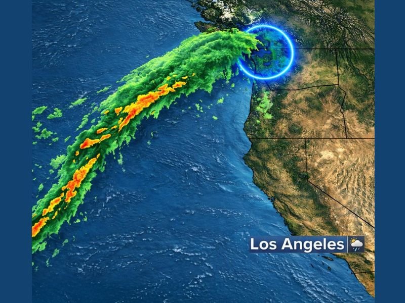
Atmospheric rivers transport concentrated bands of tropical moisture toward the West Coast, often producing widespread heavy rainfall when they make landfall. Radar and satellite imagery show the storm plume aimed directly at Washington, with additional moisture bands trailing behind — suggesting multiple rounds of rain over the next 24 to 48 hours.
Although the storm will initially impact coastal and lowland areas, inland regions could experience rapidly rising streams, overflowing drainage systems, and difficult travel conditions. The combination of saturated ground and persistent rainfall may also challenge already damaged levees and pumping systems.
Why This Matters for Midwest Readers
While this event is centered on Washington, large West Coast storm systems often influence national weather patterns, sometimes helping shape downstream conditions that eventually move into the Midwest. Illinois residents — including those in Naperville — may see shifts in late-December storm tracks tied to this Pacific system.
For ongoing updates on national storm impacts and how evolving weather patterns may affect the Midwest, stay connected with NapervilleLocal.com.

I’ve lived in Naperville long enough to see how quickly our community changes — from new developments downtown to sudden shifts in our Midwest weather. Reporting on Naperville news and daily forecasts gives me the chance to keep neighbors informed about what really matters. My goal is simple: deliver clear, timely updates so you always know what’s happening in our city and what to expect from the skies above.