
Atmospheric River to Drench Southern California With Heavy Rain, Flood Risks Through the Weekend
LOS ANGELES, CALIFORNIA – A powerful atmospheric river storm is expected to bring widespread heavy rain and potential flooding to Southern California over several days, with meteorologists warning that rainfall totals could exceed five inches in some areas before conditions improve early next week.
According to the ABC7 Los Angeles Weather Center, the rain will intensify across the Southland beginning Friday night and continue through the weekend, raising concerns for flood-prone areas, recent burn scars, and low-lying coastal zones. A second storm system may follow early next week, compounding the risk of mudslides and flash flooding in already saturated areas.
Rain Totals Could Exceed Five Inches in Key Areas
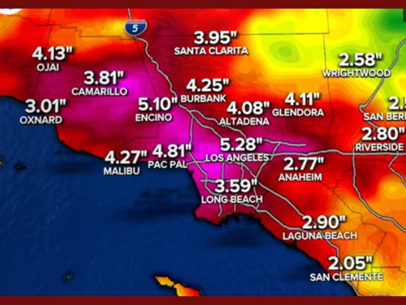
Forecast models from AccuWeather show the heaviest rain concentrating across Los Angeles County, Ventura County, and the coastal foothills. By late Sunday, projected totals include:
- Los Angeles: 5.28 inches
- Encino: 5.10 inches
- Pacific Palisades: 4.81 inches
- Burbank: 4.25 inches
- Malibu: 4.27 inches
- Ojai: 4.13 inches
- Long Beach: 3.59 inches
- Anaheim: 2.77 inches
Inland areas such as Riverside, San Bernardino, and Yucaipa are forecast to receive between 2 and 3 inches, while Big Bear Lake and other mountain communities could experience steady rainfall with cooler temperatures.
ABC7 meteorologist Brianna Ruffalo reported that the storm’s moisture stream could stall over the region, keeping rain bands moving slowly and producing periods of intense downpours. “This is a classic atmospheric river setup — warm, moist air traveling directly from the Pacific and fueling continuous rainfall across the Southland,” Ruffalo explained.
Flooding, Mudslide, and Travel Concerns
Officials have warned that urban flooding and roadway ponding are likely, especially in areas with poor drainage. Drivers are urged to avoid flooded streets and allow extra travel time throughout the weekend.
The National Weather Service has also cautioned that mudslides and debris flows could develop in burn areas, particularly in hillside communities like Glendora, Santa Clarita, and Altadena.
Public works crews in Los Angeles County are clearing storm drains and reinforcing sandbag stations ahead of the heaviest rainfall. Local authorities encourage residents to monitor alerts and take precautions if living near unstable slopes or creeks.
More Rain Ahead Next Week
While this weekend’s storm will be the first major system of the season, meteorologists are tracking a second Pacific front expected to arrive early next week. The back-to-back systems could prolong wet conditions into midweek, increasing the potential for road closures and saturated soil hazards.
The California Department of Transportation (Caltrans) is advising travelers to check conditions before heading out, especially along Interstate 5 through the Grapevine and Pacific Coast Highway, where heavy rain could trigger delays or closures.
Residents Urged to Stay Weather Aware
As the state braces for several days of rain, residents are being reminded to:
- Keep emergency kits and flashlights ready in case of power outages.
- Secure outdoor items that could blow away in gusty winds.
- Check local weather and traffic alerts before traveling.
- Use sandbags to prevent flooding around homes and garages.
Southern California’s rainfall totals are expected to make this one of the wettest early-season events in recent years, helping replenish reservoirs but also testing flood control systems across the region.
Stay connected with NapervilleLocal.com for continued updates on national weather alerts and safety reports.

I’ve lived in Naperville long enough to see how quickly our community changes — from new developments downtown to sudden shifts in our Midwest weather. Reporting on Naperville news and daily forecasts gives me the chance to keep neighbors informed about what really matters. My goal is simple: deliver clear, timely updates so you always know what’s happening in our city and what to expect from the skies above.